


98
SECTION 6
GPS Receiver
Reference
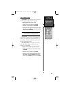
Units Setup Page
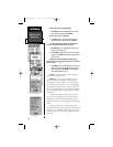
6.14.4 Units Settings
Position Format - is used to change the coordinate
system in which a given position reading is displayed.
The default format is latitude and longitude in degrees
and minutes (hddd°mm.mmm’). The following addi-
tional formats are available:
• hddd.ddddd°—latitude/longitude in
dec- imal degrees only
• hddd°mm’ss.s”—latitude/longitude in
degrees, minutes, seconds
• UTM/UPS — Universal Transverse
Mercator / Universal Polar
Stereographic grids
• British Grid • German Grid
• Irish Grid • Swedish Grid
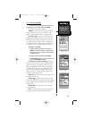
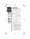
Distance & Speed
-
lets you select the desired
units of measure for distance and speed readouts in
‘Nautical’, ‘Statute’ or ‘Metric’ terms.
Heading
-
lets you select the reference used in cal-
culating heading information. You can select from ‘Auto
MV’, ‘True’, ‘Grid’ and ‘User MV’. ‘Auto MV’ provides
magnetic north heading references which are automati-
cally determined from your current position. ‘True’ pro-
vides headings based upon a true north reference.
‘Grid’ - provides headings based on a grid north
reference (and is used in conjunction with the grid
position formats.
‘User MV’ - allows you to specify the magnetic
variation at your current position and provides magnet-
ic north heading references based upon the variation
you enter.
‘Altitude’ - lets you select altitude readouts in ‘Feet’
or ‘Meters’.
WARNING: If ‘User MV’ is selected, you must period-
ically update the magnetic variation as your position
changes. Using this setting, the NavTalk will not automati-
cally calculate and update the magnetic variation at your
present position. Failure to update this setting may result
in substantial differences between the information dis-
played on your NavTalk and external references, such as a
magnetic compass.
NvTlkGPS.qxd 2/1/00 4:13 PM Page 38