


3
SECTION 1
Introduction
To NavTalk
NavTalk GPS Receiver Features
Moving Map Features
Built-In International or Americas Basemap to 20
Miles; Including Lakes, Rivers, Railroads, Coastlines,
Interstates, National and State Highways
Map Scale: 800 feet to 500 miles
MapSource
™ Compatible
Navigation Features
250 Total Waypoints, Each with Name, Symbol and
Map Display Option
Nine Continuous, Automatically Updated Nearest
Waypoints
Twenty Reversible Routes with up to 30 Waypoints
Each. Plus MOB and TracBack Modes
Cities Listings with Database Information
Interstate Exits with Services Information
106 Map Datums
Coordinates Include, Lat/Lon, UTM/UPS, and
Maidenhead.
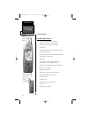
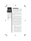
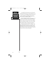
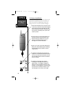
GPS/Phone
Mode Select
Map Page
Zoom IN/OUT
ON/OFF
MARK Key
LCD Display
Arrow Keypad
GOTOKey
NavTlkOM.qxd 2/1/00 2:45 PM Page 13