


Basic GPS
Using the
Simulator
SECTION 4
33
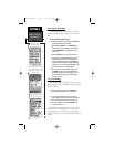
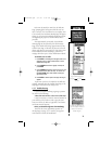
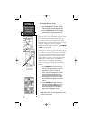
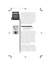
Map Page with
“North Up” orientation and
Current Scale Display.
4.5 To cycle through the main pages:
1. Press PAGE to move through each of the
main pages in normal fashion.
2. Press QUIT to move through the pages
in reverse order.
In normal mode the unit would automati-
cally sequence from the Satellite Status Page to
the Map Page once enough satellites were
received to determine your position. At that
point the receiver would be ready to use for
navigation. Because the unit is in simulation,
you won’t see this sequencing, but you will see
simulation of signal strength and other attrib-
utes of satellite reception simulated on the
Satellite Status Page.
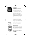
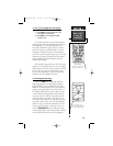
The Position Page will show the last known
position as a starting location. If you’ve already
initialized the unit, the starting location should
be very near to your current position. Now,
move to the Map Page to create a destination
and learn about navigation features.
4.6 Selecting the Map Page.
Press the PAGE key repeatedly until the
Map Page appears.The Map Page combines
digital charting with a number of selectable
features. The map display shows your present
position using a pointer icon in the center of
the display. Map features such as lakes, rivers,
towns, railways, background roads and high-
ways are shown as well as your present posi-
tion and nearby waypoints. The map can be
oriented with the top of the map always point-
ing north (‘North Up’) or it can automatically
rotate to keep your current direction of travel
at the top of the screen (‘Track Up’). You can
use the ZOOM IN/OUT keys to adjust the map
to the desired scale. The current scale is shown
in the lower left-hand corner of the display.
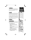
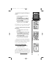
Position Page with
simulated data.
Note “Sim” indicator on
right side of Status Bar
NavTlkOM.qxd 2/1/00 2:45 PM Page 43