


trails 7
P
Perspective 3D 34
photos, aerial 5
position, tracking 27
position report 27
power key 36
powerboat 2, 12, 39
preferred data source 25
premium charts 4, 5, 7
aerial photos 5
Fish Eye 3D 7
tide and current indicators 4
product registration 41
product support 1
contact information 1
R
radar 20, 21, 23
AIS 22
bird mode 23
clutter 24
color scheme 24
custom park position 23
echo trails 24
field of view 24
front-of-boat offset 24
gain 23
MARPA 6
optimizing display 23
overlay screen 22, 23
range 21
range rings 24
sentry mode 21
source 25
timed transmit 21
tracks, Fish Eye 3D 6
transmitting 21
waypoints 6, 21, 24
zoom scale 21
radar overlay 22
radio, SiriusXM 31
range rings 7
registering the device 41
remote control 40
disconnecting 40
resetting
settings 31
station layouts 2
Route To 8
routes
copying 40
creating 9
deleting 10
editing 10
navigating 10
navigating parallel to 10
synchronizing 12
viewing list of 10
waypoints 40
S
safe depth 37
safe height 37
safe-zone collision alarm 6, 39
sailboat 2, 12, 39
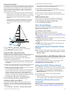
sailing 7, 13
race timer 13
starting line 13
sailing gauges 28
sailingstarting line 13
SART 6
satellite imagery 5
satellite signals, acquiring 1
screen, brightness 2
screenshots 41
capturing 41
sentry mode 21
guard zone 21
timed transmit 21
settings 36–38
radar display 24
system information 36
Shadow Drive, enabling 25
shoreline distance 11, 37
SideVü 15
SiriusXM 32
Satellite Radio 31
SiriusXM Satellite Radio 31
software
updates 1
updating 1
software license agreement 42
sonar 14, 16, 19
a-scope 18, 19
alarms 19
appearance 19
bottom lock 17
color gain 17
color rejection 19
cone 7
depth 17
depth scale 17
DownVü 14
frequencies 17, 18
gain 16
interference 19
measuring distances 16
noise 16, 17
Panoptix 15, 16, 18, 19
recording 20
scroll speed 18
sharing 16
SideVü 15
source 16
surface noise 19
suspended targets 19
views 14–16
waypoint 16
whiteline 19
zoom 17
SOS 8, 27
stations 1
changing the station 36
customizing the home screen of 2
ordering the displays 36
restoring the layout 2, 36
suspended targets 7
symbols 5
synchronizing, user data 12
system information 36, 41
T
tacking and gybing 14
heading hold 14
wind hold 14
targeting 21
temperature log 29
tide stations 4, 29
indicators 4
tracks 11, 12
clearing 12
copying 40
deleting 12
editing 12
list 12
navigating 12
recording 12
saving 12
saving as route 12
showing 7, 11
transducer 14, 18–20
trip gauges 29
troubleshooting 41
U
unit ID 36
units of measure 37
updates, software 1
user data
deleting 12
synchronizing 12
V
vessel trails 7, 27
VHF radio 26
calling an AIS target 27
distress calls 26, 27
DSC channel 27
individual routine call 27
video 34–36
configuring 34, 35
source 34, 35
viewing 34, 35
voltage 38
VRM 22
adjusting 22
measuring 22
showing 22
W
warning manager 29
messages 29, 30
water
speed 39
temperature log 29
temperature offset 39
waypoints 8, 41
copying 40
creating 3, 8, 34
deleting 9
editing 9
man overboard 8
navigating to 9
radar 21
showing 7
sonar 16
synchronizing 12
tracked vessel 27
viewing list of 9
weather 34
weather 7, 32
alarms 38
broadcasts 32
charts 32, 34
fishing 33
fishing chart 34
forecast 32–34
navigation chart 34
overlay 34
precipitation 32
sea conditions 33
subscription 31, 34
surface pressure 33
visibility 33
water temperature 33
wave information 33
winds 33
Wi‑Fitechnology 39
wind angle graph 29
wind gauges 28, 29
wind hold 14
adjusting 14
wind speed graph 29
wireless devices 36, 39, 40
connecting a wireless device 39, 40
network configuration 39, 40
Z
zoom
chart 3
radar 21
sonar 17
Index 45