


Units: Sets units of measure.
Language: Sets the on-screen text language.
Navigation: Sets navigation preferences.
Keyboard Layout: Arranges the keys on the on-screen
keyboard.
Screenshot Capture: Allows the device to save images of the
screen.
User Data Sharing: Allows you to share waypoints and routes
over the Garmin Marine Network. All chartplotters that share
waypoints and routes must have this setting turned on.
Menu Bar Display: Shows or automatically hides the menu bar
when it is not needed.
Units Settings
Select Settings > Preferences > Units.
System Units: Sets the unit format for the device.
Variance: Sets the magnetic declination, the angle between
magnetic north and true north, for your present location.
North Reference: Sets the direction references used in
calculating heading information. True sets geographic north
as the north reference. Grid sets grid north as the north
reference (000º). Magnetic sets the magnetic north as the
north reference.
Position Format: Sets the position format in which a given
location reading appears. Do not change this setting unless
you are using a map or chart that specifies a different
position format.
Map Datum: Sets the coordinate system on which the map is
structured. Do not change this setting unless you are using a
map or chart that specifies a different map datum.
Time: Sets the time format, time zone, and daylight saving time.
Navigation Settings
NOTE: Some settings and options require additional charts or
hardware.
Select Settings > Preferences > Navigation.
Route Labels: Sets the type of labels shown with route turns on
the map.
Turn Transition: Adjusts how the chartplotter transitions to the
next turn or leg or the route. You can set the transition to be
based on time or distance before the turn. You can increase
the time or distance value to help improve the accuracy of the
autopilot when navigating a route or an Auto Guidance line
with many frequent turns or at higher speeds. For straighter
routes or slower speeds, lowering this value can improve
autopilot accuracy.
Auto Guidance: Sets the measurements for the Safe Depth,
Safe Height, and Shoreline Distance, when you are using
some premium maps.
Route Start: Selects a starting point for route navigation.
Auto Guidance Line Configurations
CAUTION
The Safe Depth and Safe Height settings influence how the
chartplotter calculates an Auto Guidance line. If an area has an
unknown water depth or an unknown obstacle height, the Auto
Guidance line is not calculated in that area. If an area at the
beginning or the end of an Auto Guidance line is shallower than
the safe water depth or lower than the safe obstacle height, the
Auto Guidance line is not calculated in that area. On the chart,
the course through those areas appears as a gray line. When
your boat enters one of those areas, a warning message
appears.
NOTE: Auto Guidance is available with premium charts, in some
areas.
You can set the parameters the chartplotter uses when
calculating an Auto Guidance line.
Safe Depth: Sets the minimum depth (chart depth datum) the
chartplotter uses when calculating an Auto Guidance line.
NOTE: The minimum safe depth for the premium charts is 3
feet. If you enter a Safe Depth value of less than 3 feet, the
charts only use depths of 3 feet for Auto Guidance route
calculations.
Safe Height: Sets the minimum height (chart height datum) of a
bridge that your boat can safely travel under.
Shoreline Distance: Sets how close to the shore you want the
Auto Guidance line to be placed. The Auto Guidance line
may move if you change this setting while navigating. The
available values for this setting are relative, not absolute. To
ensure that the Auto Guidance line is placed the appropriate
distance from shore, you can assess the placement of the
Auto Guidance line using one or more familiar destinations
that require navigation through a narrow waterway (Adjusting
the Distance from Shore, page 11).
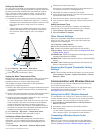
Adjusting the Distance from Shore
The Shoreline Distance setting indicates how close to the shore
you want the Auto Guidance line to be placed. The Auto
Guidance line may move if you change this setting while
navigating. The available values for the Shoreline Distance
setting are relative, not absolute. To ensure the Auto Guidance
line is placed the appropriate distance from shore, you can
assess the placement of the Auto Guidance line using one or
more familiar destinations that require navigation through a
narrow waterway.
1
Dock your vessel or drop the anchor.
2
Select Settings > Preferences > Navigation > Auto
Guidance > Shoreline Distance > Normal.
3
Select a destination that you have navigated to previously.
4
Select Navigate To > Auto Guidance.
5
Review the placement of the Auto Guidance line, and
determine whether the line safely avoids known obstacles
and the turns enable efficient travel.
6
Select an option:
• If the placement of the Auto Guidance line is satisfactory,
select Menu > Navigation Options > Stop Navigation,
and proceed to step 10.
• If the Auto Guidance line is too close to known obstacles,
select Settings > Preferences > Navigation > Auto
Guidance > Shoreline Distance > Far.
• If the turns in the Auto Guidance line are too wide, select
Settings > Preferences > Navigation > Auto Guidance
> Shoreline Distance > Near.
7
If you selected Near or Far in step 6, review the placement of
the Auto Guidance line, and determine whether the line
safely avoids known obstacles and the turns enable efficient
travel.
Auto Guidance maintains a wide clearance from obstacles in
open water, even if you set the Shoreline Distance setting to
Near or Nearest. As a result, the chartplotter may not
reposition the Auto Guidance line, unless the destination
selected requires navigation through a narrow waterway.
8
Select an option:
• If the placement of the Auto Guidance line is satisfactory,
select Menu > Navigation Options > Stop Navigation,
and proceed to step 10.
• If the Auto Guidance line is too close to known obstacles,
select Settings > Preferences > Navigation > Auto
Guidance > Shoreline Distance > Farthest.
Device Configuration 37