


• If the turns in the Auto Guidance line are too wide, select
Settings > Preferences > Navigation > Auto Guidance
> Shoreline Distance > Nearest.
9
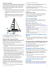
If you selected Nearest or Farthest in step 8, review the
placement of the Auto Guidance line, and determine
whether the line safely avoids known obstacles and the turns
enable efficient travel.
Auto Guidance maintains a wide clearance from obstacles in
open water, even if you set the Shoreline Distance setting to
Near or Nearest. As a result, the chartplotter may not
reposition the Auto Guidance line, unless the destination
selected requires navigation through a narrow waterway.
10
Repeat steps 3 through 9 at least once more, using a
different destination each time, until you are familiar with the
functionality of the Shoreline Distance setting.
Communications Settings
NMEA 0183 Settings
Select Settings > Communications > NMEA 0183 Setup.
Port Types: See Setting the Communication Format for Each
NMEA 0183 Port, page 38.
Output Sentences: See Configuring NMEA 0183 Output
Sentences, page 38.
Position Precision: Adjusts the number of digits to the right of
the decimal point for transmission of NMEA output.
XTE Precision: Adjusts the number of digits to the right of the
decimal point for NMEA crosstalk error output.
Waypoint IDs: Sets the device to transmit waypoint names or
numbers via NMEA 0183 while navigating. Using numbers
may resolve compatibility issues with older NMEA 0183
autopilots.
Defaults: Restores the NMEA 0183 settings to the original
factory defaults.
Diagnostics: Displays NMEA 0183 diagnostic information.
Configuring NMEA 0183 Output Sentences
You can enable and disable NMEA 0183 output sentences.
1
Select Settings > Communications > NMEA 0183 Setup >
Output Sentences.
2
Select an option.
3
Select one or more NMEA 0183 output sentences, and select
Back.
4
Repeat steps 2 and 3 to enable or disable additional output
sentences.
Setting the Communication Format for Each NMEA 0183
Port
You can configure the communication format for each internal
NMEA 0183 port when connecting your chartplotter to external
NMEA 0183 devices, a computer, or other Garmin devices.
1
Select Settings > Communications > NMEA 0183 Setup >
Port Types.
2
Select an input or output port.
3
Select a format:
• To support the input or output of standard NMEA 0183
data, DSC, and sonar NMEA input support for the DPT,
MTW, and VHW sentences, select NMEA Std..
• To support the input or output of standard NMEA 0183
data for most AIS receivers, select NMEA High Speed.
• To support the input or output of Garmin proprietary data
for interfacing with Garmin software, select Garmin.
4
Repeat steps 2–3 to configure additional input or output
ports.
NMEA 2000 Settings
Select Settings > Communications > NMEA 2000 Setup.
Device List: Displays the devices connected to the network.
Label Devices: Changes the labels for available connected
devices.
Garmin Marine Network
The Garmin Marine Network allows you to share data from
Garmin peripheral devices with the chartplotters quickly and
easily. You can connect a chartplotter to a Garmin Marine
Network to receive data from and share data with other Garmin
Marine Network-compatible devices and chartplotters.
Setting Alarms
Navigation Alarms
Select Settings > Alarms > Navigation.
Arrival: Sets an alarm to sound when you are within a specified
distance or time from a turn or a destination.
Anchor Drag: Sets an alarm to sound when you exceed a
specified drift distance while anchored.
Off Course: Sets an alarm to sound when you are off course by
a specified distance.
System Alarms
Alarm Clock: Sets an alarm clock.
Unit Voltage: Sets an alarm to sound when the battery reaches
a specified low voltage.
GPS Accuracy: Sets an alarm to sound when the GPS location
accuracy falls outside the user-defined value.
Setting the Fuel Alarm
Before you can set a fuel level alarm, a compatible fuel flow
sensor must be connected to the NMEA 2000 network.
You can set an alarm to sound when the total amount of
remaining onboard fuel reaches the level you specify.
1
Select Settings > Alarms > Fuel > Fuel Level Alarm > On.
2
Enter the remaining amount of fuel that triggers the alarm.
Setting Weather Alarms
Before you can set weather alarms, you must have a compatible
chartplotter connected to a weather device, such as a GXM
device, and have a valid weather subscription.
1
Select Settings > Alarms > Weather.
2
Turn on alarms for specific weather events.
My Vessel Settings
NOTE: Some settings and options require additional charts or
hardware.
Select Settings > My Vessel.
Keel Offset: Offsets the surface reading for the depth of a keel,
making it possible to measure depth from the bottom of the
keel instead of from the transducer location (Setting the Keel
Offset, page 13).
Temperature Offset: Compensates for the water temperature
reading from a NMEA 0183 water-temperature sensor or a
temperature-capable transducer (Setting the Water
Temperature Offset, page 39).
Calibrate Water Speed: Calibrates the speed-sensing
transducer or sensor (Calibrating a Water Speed Device,
page 39).
Fuel Capacity: Sets the combined fuel capacity of all the fuel
tanks on your vessel (Setting the Fuel Capacity of the Vessel,
page 28).
Vessel Type: Enables some chartplotter features based on the
boat type.
38 Device Configuration