


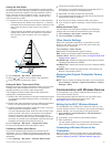

point does not appear where the point should be, the map
datum and position format of the device may not match the map
datum and position format originally used to mark the waypoint.
Position format is the way in which the GPS receiver's position
appears on the screen. Commonly displayed as latitude/
longitude in degrees and minutes, with options for degrees,
minutes and second, degrees only, or one of several grid
formats.
Map datum is a math model which depicts a part of the surface
of the earth. Latitude and longitude lines on a paper map are
referenced to a specific map datum.
1
Find out which map datum and position format was used
when the original waypoint was created.
If the original waypoint was taken from a map, there should
be a legend on the map that lists the map datum and position
format used to create that map. Most often this is found near
the map key.
2
On the chartplotter, select Settings > Preferences > Units.
3
Select the correct map datum and position format settings.
4
Create the waypoint again.
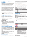
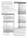
NMEA 0183 Information
Type Sentence Description
Transmit GPAPB APB: Heading or track controller (autopilot)
sentence "B"
GPBOD BOD: Bearing (origin to destination)
GPBWC BWC: Bearing and distance to waypoint
GPGGA GGA: Global positioning system fix data
GPGLL GLL: Geographic position (latitude and longitude)
GPGSA GSA: GNSS DOP and active satellites
GPGSV GSV: GNSS satellites in view
GPRMB RMB: Recommended minimum navigation
information
GPRMC RMC: Recommended minimum specific GNSS
data
GPRTE RTE: Routes
GPVTG VTG: Course over ground and ground speed
GPWPL WPL: Waypoint location
GPXTE XTE: Cross track error
PGRME E: Estimated error
PGRMM M: Map datum
PGRMZ Z: Altitude
SDDBT DBT: Depth below transducer
SDDPT DPT: Depth
SDMTW MTW: Water temperature
SDVHW VHW: Water speed and heading
Receive DPT Depth
DBT Depth below transducer
MTW Water temperature
VHW Water speed and heading
WPL Waypoint location
DSC Digital selective calling information
DSE Expanded digital selective calling
HDG Heading, deviation, and variation
HDM Heading, magnetic
MWD Wind direction and speed
MDA Meteorological composite
MWV Wind speed and angle
VDM AIS VHF data-link message
NMEA 2000 PGN Information
Type PGN Description
Transmit and
receive
059392 ISO acknowledgment
059904 ISO request
060928 ISO address claim
126208 NMEA: Command, request, and
acknowledge group function
126464 Transmit and receive PGN list group
function
126996 Product information
129026 COG and SOG : Rapid update
129029 GNSS position data
129540 GNSS satellites in view
130306 Wind data
130312 Temperature
Transmit 127250 Vessel heading
127258 Magnetic variance
128259 Speed: Water referenced
128267 Water depth
129025 Position: Rapid update
129283 Cross track error
129284 Navigation data
129285 Navigation route and waypoint info
Receive 126992 System time
127250 Vessel heading
127489 Engine parameters: Dynamic
127488 Engine parameters: Rapid update
127493 Transmission parameters: Dynamic
127505 Fluid level
128259 Speed: water referenced
128267 Water depth
129025 Position: rapid update
129038 AIS class A position report
129039 AIS class B position report
129040 AIS class B extended position report
129539 GNSS DOPs
129794 AIS class A static and voyage related
data
129809 AIS class B "CS" static data report, part
A
129810 AIS class B "CS" static data report, part
B
130310 Environmental parameters
130311 Environmental parameters
130313 Humidity
130314 Actual pressure
Software License Agreement
BY USING THE DEVICE, YOU AGREE TO BE BOUND BY THE
TERMS AND CONDITIONS OF THE FOLLOWING SOFTWARE
LICENSE AGREEMENT. PLEASE READ THIS AGREEMENT
CAREFULLY.
Garmin Ltd. and its subsidiaries (“Garmin”) grant you a limited
license to use the software embedded in this device (the
“Software”) in binary executable form in the normal operation of
the product. Title, ownership rights, and intellectual property
rights in and to the Software remain in Garmin and/or its third-
party providers.
You acknowledge that the Software is the property of Garmin
and/or its third-party providers and is protected under the United
States of America copyright laws and international copyright
treaties. You further acknowledge that the structure,
42 Appendix