


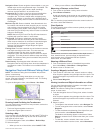
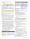
Sonar Cone: Shows a cone that indicates the area covered by
the transducer.
Fish Symbols: Shows suspended targets.
Navigation with a Chartplotter
CAUTION
If your vessel has an autopilot system, a dedicated autopilot
control display must be installed at each steering helm in order
to disable the autopilot system.
The Auto Guidance feature is based on electronic chart
information. That data does not ensure obstacle and bottom
clearance. Carefully compare the course to all visual sightings,
and avoid any land, shallow water, or other obstacles that may
be in your path.
When using Go To, a direct course and a corrected course may
pass over land or shallow water. Use visual sightings, and steer
to avoid land, shallow water, and other dangerous objects.
NOTE: Auto Guidance is available with premium charts, in some
areas.
NOTE: Mariner's Eye 3D and Fish Eye 3D chart views are
available with premium charts, in some areas.
NOTE: The offshore Fishing chart is available with premium
charts, in some areas.
To navigate, you must choose a destination, set a course or
create a route, and follow the course or route. You can follow
the course or the route on the Navigation chart, Fishing chart,
Perspective 3D chart view, or Mariner’s Eye 3D chart view.
You can set and follow a course to a destination using one of
three methods: Go To, Route To, or Auto Guidance.
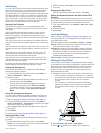
Go To: Takes you directly to the destination. This is the
standard option for navigating to a destination. The
chartplotter creates a straight-line course or navigation line to
the destination. The path may run over land and other
obstacles.
Route To: Creates a route from your location to a destination,
allowing you to add turns along the way. This option provides
a straight-line course to the destination, but allows you to add
turns into the route to avoid land and other obstacles.
Auto Guidance: Creates a path to a destination using Auto
Guidance. This option is available only when using a
compatible premium chart in a compatible chartplotter. It
provides a turn-by-turn navigation line to the destination,
avoiding land and other obstacles. The navigation line is
based on the chart data and the safe depth, safe height, and
shoreline distance user-defined chartplotter settings. Using
these settings and chart data, the chartplotter creates a
navigation line that avoids all areas that cannot be navigated
between the present location and the destination.
When you are using a compatible Garmin autopilot
connected to the chartplotter using NMEA 2000
®
, the
autopilot follows the Auto Guidance route.
Basic Navigation Questions
Question Answer
How do I make the
chartplotter point me in the
direction in which I want to go
(bearing)?
Navigate using Go To. See Setting and
Following a Direct Course Using Go To,
page 9.
How do I make the device
guide me along a straight line
(minimizing cross track) to a
location using the shortest
distance from the present
location?
Build a single-leg route and navigate it
using Route To. See Creating and
Navigating a Route From Your Present
Location, page 9.
Question Answer
How do I make the device
guide me to a location while
avoiding charted obstacles?
Build a multi-leg route and navigate it
using Route To. See Creating and
Navigating a Route From Your Present
Location, page 9.
How do I make the device
steer my automatic pilot?
Navigate using Route To. See Creating
and Navigating a Route From Your
Present Location, page 9.
Can the device create a path
for me?
If you have premium maps that support
Auto Guidance and are in an area
covered by Auto Guidance, navigate
using Auto Guidance. See Setting and
Following an Auto Guidance Path,
page 10.
How do I change the Auto
Guidance settings for my
boat?
See Auto Guidance Line
Configurations, page 11.
Destinations
You can select destinations using various charts and 3D chart
views or using the lists.
Searching for a Destination by Name
You can search for saved waypoints, saved routes, saved
tracks, and marine services destinations by name.
1
Select Info > Services > Search by Name.
2
Enter at least a portion of the name of your destination.
3
If necessary, select Done.
The 50 nearest destinations that contain your search criteria
appear.
4
Select the destination.
Selecting a Destination Using the Navigation Chart
From the Navigation chart, select a destination.
Searching for a Marine Services Destination
NOTE: This feature is available with premium charts, in some
areas.
The chartplotter contains information for thousands of
destinations offering marine services.
1
Select Info > Services.
2
Select Offshore Services or Inland Services.
3
If necessary, select the marine service category.
The chartplotter shows a list of the nearest locations and the
distance and bearing to each.
4
Select a destination.
You can select Next Page or Previous Page to view
additional information or to show the location on a chart.
Waypoints
Waypoints are locations you record and store in the device.
Marking Your Present Location as a Waypoint
From any screen, select Mark.
Creating a Waypoint at a Different Location
1
Select Info > User Data > Waypoints > Create Waypoint.
2
Select an option:
• To create the waypoint by entering position coordinates,
select Enter Coordinates, and enter the coordinates.
• To create the waypoint using a chart, select Use Chart,
select the location, and select Select.
Marking an SOS Location
You can mark an SOS location. When a Garmin VHF radio is
connected using NMEA 2000, you can select different SOS
types, such as Man Overboard and Piracy.
8 Navigation with a Chartplotter