


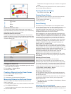

resolution, but is the most susceptible to noise. With echo
stretch set to high and filter width set to low, the display has a
lower resolution, but has wider targets. With echo stretch and
filter width set to high, the display has the lowest resolution,
but is the least susceptible to noise. It is not recommended to
set echo stretch to low and filter width to high.
Bottom Track: Sets the frequency used for determining depth.
The bottom tracking control allows you to select the specific
channel that is used to track the bottom. For example, you
can set the bottom tracking for the low frequency for deep
water operation.
Temp. Source: Sets the channel for the water temperature log
when more than one water-temperature sensor or
temperature-capable transducer is connected.
Transducer Installation Settings
From a sonar view, select Menu > Sonar Setup > Installation.
Transmit Rate: Sets the length of time between sonar pings.
Increasing the transmit rate increases the scroll speed, but it
may also increase self-interference.
Reducing the transmit rate increases the spacing between
transmit pulses and can resolve self-interference.
Transmit Power: Reduces transducer ringing near the surface.
A lower transmit power value reduces transducer ringing, but
can also reduce the strength of the returns.
Filter Width: Defines the edges of the target. A shorter filter
more clearly defines the edges of the targets but may allow
more noise. A longer filter creates softer target edges and
may also reduce noise.
Transducer Diagnostics: Shows details about the transducer.
Flip Left/Right: Switches the SideVü view orientation from left
to right.
Install Depth: Sets the depth below the water line where the
Panoptix transducer is mounted. Entering the actual depth at
which the transducer is mounted results in a more accurate
visual presentation of what is in the water.
Flipped: Sets the orientation of the Panoptix sonar view when
the down view transducer is installed with the cables pointing
toward the port side of the boat.
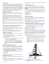
Beam Width: Sets the width of the Panoptix transducer beam.
Narrow beam widths are better for high-speed operation and
rough sea conditions. They also can improve bottom
definition and thermocline definition.
Wider beam widths generate larger arches for fish target
returns, making them ideal for locating fish. Wider beam
widths perform better in deep water. They can generate more
surface noise and reduce bottom signal continuity during
rough sea conditions.
Use AHRS: Enables the internal attitude heading and reference
system (AHRS) sensors to detect the installation angle of the
Panoptix transducer automatically. When this setting is
turned off, you can enter the specific installation angle for the
transducer using the Pitch Angle setting. Many forward view
transducers are installed at a 45-degree angle and down
view transducers are installed at a zero-degree angle.
Sonar Recordings
Recording the Sonar Display
NOTE: Not all models support sonar recording.
1
Insert a memory card into the card slot.
2
From a sonar view, select Menu > Sonar Setup > Sonar
Recording > Record Sonar.
15 minutes of sonar recording uses approximately 200 MB of
space of the inserted memory card. You can record sonar
until the card reaches capacity.
Stopping the Sonar Recording
Before you can stop recording sonar, you must begin recording
it (Recording the Sonar Display, page 20).
From a sonar view, select Menu > Sonar Setup > Sonar
Recording > Stop Recording.
Deleting a Sonar Recording
1
Insert a memory card into the card slot.
2
From a sonar view, select Menu > Sonar Setup > Sonar
Recordings > View Recordings.
3
Select a recording.
4
Select Delete.
Playing Sonar Recordings
Before you can play back the sonar recordings, you must
download and install the HomePort
™
application and record
sonar data onto a memory card.
1
Remove the memory card from the device.
2
Insert the memory card into a card reader attached to a
computer.
3
Open the HomePort application.
4
Select a sonar recording from your device list.
5
Right-click the sonar recording in the lower pane.
6
Select Playback.
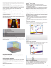
Radar
WARNING
The marine radar transmits microwave energy that has the
potential to be harmful to humans and animals. Before
beginning radar transmission, verify that the area around the
radar is clear. The radar transmits a beam approximately 12°
above and below a line extending horizontally from the center of
the radar.
When the radar is transmitting, do not look directly at the
antenna at close range; eyes are the most sensitive part of the
body to electromagnetic energy.
NOTE: Not all models support radar.
When you connect your compatible chartplotter to an optional
Garmin marine radar, such as a GMR
™
1226 xHD2 or a GMR 24
HD, you can view more information about your surroundings.
The GMR transmits a narrow beam of microwave energy as it
rotates to a 360° pattern. When the transmitted energy contacts
a target, some of that energy is reflected back to the radar.
Radar Display Modes
NOTE: Not all modes are available with all radar devices and all
chartplotters.
Select Radar.
Cruising Mode: Shows a full-screen image of the gathered
radar information.
Harbor Mode: Intended for use in inland waters, this mode
works best with short-range signals (2 nm or less).
Offshore Mode: Intended for use in open waters, this mode
works best with long-range signals.
Sentry Mode: Allows you to put the radar into timed-transmit
mode, in which you can configure a radar transmit and
standby cycle to conserve power. You can also enable a
guard zone in this mode, which identifies a safe zone around
your boat. If you switch from Sentry mode to another mode,
the radar switches to full-time transmission and disables all
guard zones.
Radar Overlay Mode: Shows a full-screen image of the
gathered radar information on top of the Navigation chart.
20 Radar