


8. CUSTOMIZING YOUR UNIT
8-2
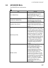
DATE FORMAT
Chooses date notation; MM-DD-YY or DD-MM-YY.
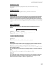
AUTO INFO
Chooses what data is available with the cursor; Off, On Points or On All.
On Points: Data for selected chart symbol, for example, lighthouse or harbor.
All Points: Data for any location within the area covered by the chart.
SHIP ICON
Chooses the shape of own ship marker;
,or
+
.
WIND GRAPH
See section 2.10 for details about the wind display.
UNITS OF MEASURE
Chooses unit of measurement for distance, speed, depth, altitude and
temperature.
Distance: nm, sm, km, nm + ft, nm + m, sm + ft
(For “+ft” and “+m, ” it is used in the near range.)
Speed: Kt, mph, km/h
Depth: ft, fa, m, pb
Altitude: ft, fl, m
Temperature: C, F
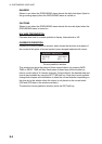
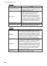
8.2 MAP Menu
The MAP menu sets up the map display.
ZOOM TYPE Standard
FONTS & SYMBOLS NORMAL
PERSPECTIVE VIEW Off
DYNAMIC NAV-AIDS Off
MIXING LEVELS On
SAFETY STATUS BAR Off
NAV AIDS PRESENTATION US
CURRENTS PREDICTION
MAP CONFIGURATIONS
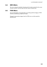
Map menu
ZOOM TYPE
Chooses the zoom type between Standard and Flexi-Zoom.
Standard: Normal zoom function
Flexi-Zoom: Shows the scale indication.
FONTS & SYMBOLS
Chooses the size of landmarks and their names, between NORMAL and
LARGE.