


2. PLOTTER DISPLAY
2-8
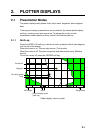
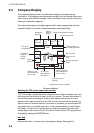
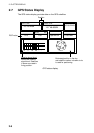
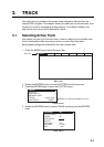
2.7 GPS Status Display
The GPS status display provides data on the GPS satellites.
33 18.426N
12:09 AM
1.00
Apr/02/04
ACQUIRING
LONGITUDE
LATITUDE
HDOP
SOG Kts
DATE
TIME
131 48.608W
12.5
07 14 25 31 -- --
01 11 20 28 -- --
07
01
11
14
25
31
28
Position
DOP value
Receive signal level:
Bars show satellite
signal level. Satellites
in brown are used in
fixing position.
Estimated position in the sky,
and satellite number in brown circle
is used for positioning.
GPS status display