


20
21
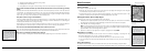
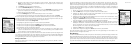
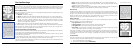
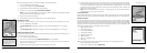
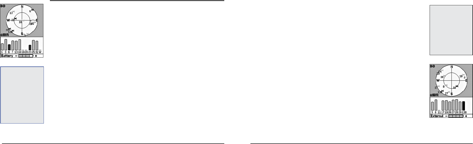
The Satellites Page
Viewing the Satellites Page
Once you turn on the Earthmate GPS PN-20, the Satellites Page displays. The Satellites Page informs
you of your current GPS status, the number of satellites the Earthmate GPS PN-20 is acquiring data
from, the signal strength, and the GPS accuracy (available only when a 2-D or 3-D fix is obtained).
GPS and WAAS Status
GPS status displays in the upper-left corner of the page and displays the following, depending on your
satellite acquisition status:
• GPS Off—The GPS is disabled.
• No Fix—The GPS cannot find sufficient satellite data to determine your current GPS position.
• 2-D—The GPS connection is successful, but the connection quality is not quite as sufficient as a
3-D fix. This usually indicates insufficient data for an accurate location because only three
satellites are being used or signals from the satellites are poor. Move your receiver to another
location until you get better reception.
• 3-D—The GPS receiver is receiving sufficient satellite data to determine your location.
If WAAS displays in the upper-right corner of the page, the Earthmate GPS PN-20 has obtained a
WAAS connection. WAAS provides up to five times greater position accuracy than a regular 2-D or
3-D connection. WAAS is available only in North America.
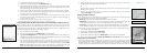
Satellite Constellation and Signal Graph
Both the satellite constellation and the satellite signal graph display visible satellites and their identify-
ing numbers, which are assigned by the Department of Defense.
In the satellite constellation, satellite-shaped icons display each satellite’s position in the sky relative
to the device’s current position.
In the satellite signal graph, each satellite is represented as a bar that is sized according to signal
strength. Longer bars have greater strength and shorter bars have less strength.
The icons in the satellite constellation and the lines in the signal graph are color coded based on the
quality of the data they are transmitting:
• Red—Indicates your GPS receiver is tracking the satellite, but it is not receiving data from it.
• Green—Indicates your GPS receiver is tracking the satellite, ephemeris data is available, and the
satellite is being used for navigation.
• Blue—Indicates your receiver is tracking the satellite, ephemeris data is available, the satellite is
being used for navigation, and the satellite has WAAS corrections available.
GPS Accuracy
The GPS accuracy displays in the lower-left corner of the screen in feet or meters, depending on the
measurement preferences you assigned in the Device Setup Page (see To Modify the Units Settings
on page 71 for more information). GPS accuracy is represented on the map by a circle with a radius
equal to the GPS accuracy, allowing you to see a representation of your accuracy in relation to your
map scale. The accuracy of the Earthmate GPS PN-20 is +/- 10 meters.
Battery Indicator
The battery indicator is a graphic representation of the current available battery power. It displays
differently based on the current available power:
• Four green bars—Indicates a full charge.
• Three green bars—One quarter of the battery power has been used.
• Two yellow bars—One half of the battery power has been used.
• One red bar—Three quarters of the battery power has been used. Once the battery has reached
5% of its total battery power, a low battery warning displays.
While the Li-Ion battery is charging, the battery indicator graphic is animated and the word “Battery”
is replaced with “Charging.” Once the battery is fully charged, the battery indicator graphic displays
four static green bars and the word “Charging” is replaced with “External” until the charging cable
is removed.
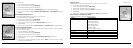
To Disable GPS
There are many features on the Earthmate GPS PN-20 that do not require a GPS fix. You can turn off
the GPS connection using the Disable GPS option in the Satellites menu.
1. From the Satellites Page, press MENU.
2. Use the arrow keypad to highlight Disable GPS.
The Satellites Page
Batteryindicatorlabelchanges
to “external” when charging
Note: WAAS was developed
by the Federal Aviation Admin-
istration to enhance the accu-
racy—usually to within three
meters of actual position—of
GPS receivers by providing
a modiedGPS signal. After
calculating the error factor
at ground control stations
throughout the U.S., the cor-
rected signal is transmitted to
two geostationary satellites
thatinturntransmit theGPS
signalbacktoEarth.
Satellites Page
Tip: If it is taking a long time for
the device to obtain a 2-D or 3-D
x, verify it has a clear view
ofthesky.Besurethattrees,
buildings, and other obstacles
arenotblockingtheEarthmate
GPSPN-20.Ifthedevicestill
cannot obtain a 2-D/3-D x,
pressPAGEuntiltheSatellites
Page displays, press MENU,
highlight the Set Current Lo-
cation option, and then press
ENTER.TheMapPagedisplays
automatically. Pan the map to
your current location and press
ENTER.