


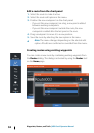
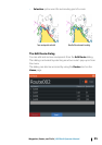
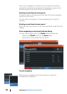
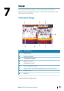

Key Description
5 Bearing line with allowed off course limit
When travelling on a route the bearing line shows the
intended course from one waypoint towards the next.
When navigating towards a waypoint (cursor position,
MOB, or an entered latitude and longitude position), the
bearing line shows the intended course from the point at
which navigation was started towards the waypoint.
6 Vessel symbol
Indicates distance and bearing relative to the intended
course. If the XTE (Cross Track Error) exceeds the defined
XTE limit, this is indicated with a red arrow including the
distance from the track line. Refer to ""XTE limit" on page
61".
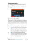
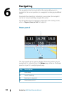
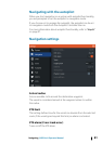
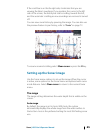
Data Fields
The Steer panel provides the following information:
XTE Cross track error
SOG Speed over ground
COG Course over ground
POS Position
DTD Distance to destination
TTD Time to destination
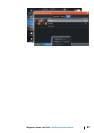
Navigate to cursor position
You can start navigating to a cursor position on any chart, radar, or
Sonar panel.
Position the cursor at the selected destination on the panel, and
then select the Goto Cursor option in the menu.
Navigate a route
You can start navigating a route from the chart panel, steer panel, or
from the Route dialog.
Navigating | HDS Gen3 Operator Manual
59