


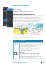
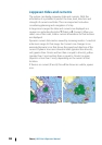
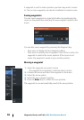

Jeppesen tides and currents
The system can display Jeppesen tides and currents. With this
information it is possible to predict the time, level, direction and
strength of currents and tides. This is an important tool when
considering planning and navigation of a trip.
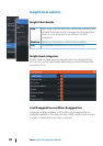
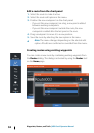
In large zoom ranges the tides and currents are displayed as a
square icon including the letter T (Tides) or C (Current). When you
select one of the icons, tidal or current information for that location
are displayed.
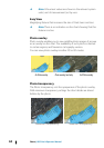
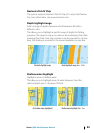
Dynamic current data can be viewed by zooming inside a 1-nautical
mile zoom range. At that range, the Current icon changes to an
animated dynamic icon that shows the speed and direction of the
current. Dynamic icons are colored in black (greater than 6 knots),
red (greater than 2 knots and less than or equal to 6 knots), yellow
(greater than 1 knot and less than or equal to 2 knots) or green
(equal to or less than 1 knot), depending on the current in that
location.
If there is no current (0 knots) this will be shown as a white, square
icon.
Static Current and Tide icons Dynamic Current icons
46
Charts | HDS Gen3 Operator Manual