


Ú
Note: You must have a SIRIUS data package subscription to
search for fueling stations and an AIS receiver connected to
search for vessels.
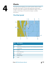
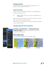
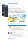
3D charts
The 3D option provides a three dimensional graphical view of land
and sea contours.
Ú
Note: All chart types work in 3D mode, but without 3D
cartography for the appropriate area the chart appears flat.
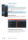
When 3D chart option is selected, the Pan and the Rotate icons
appear on the right side of the chart panel.
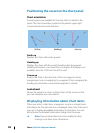
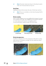
Panning the 3D chart
You can move the chart in any direction by selecting the Pan icon
and then panning in the desired direction.
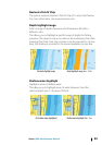
Controlling the view angle
You can control the view angle by selecting the Rotate icon and
then panning the chart panel.
• To change the direction you are viewing, pan horizontally
• To change the tilt angle of the view, pan vertically
Ú
Note: When centered on the vessel position, only the tilt
angle can be adjusted. The view direction is controlled by
the chart orientation setting. See "Positioning the vessel on the chart
panel" on page 36.
38
Charts | HDS Gen3 Operator Manual