


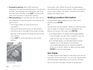
30
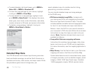
The Map Page
displays; if it doesn't, select it from the Chart list on the
Navionics Setup page.
From the Map Page, go to MENU > Turn Charts On
or Turn Charts Off.
Note This menu option controls the Show Charts
and Show Boundaries check boxes on the Navionics
Setup page.
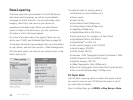
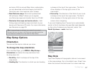
Navionics Setup
Customize the way Navionics charts appear on your
PN-60. To access all of these options, go to MENU >
Map Setup > Navionics Setup.
To select a chart
From the Navionics Setup page, select the chart or map
you want to use from the Chart drop-down list.
To view a chart or map
To view the chart or map selected in the Chart
drop-down list on the device, click View Chart.
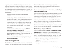
To show charts or boundaries
Control how you view charts and their boundaries
on the map—view charts alone, boundaries alone,
or both together.
To show charts, select the Show Charts check box.
To show boundaries, select the Show Boundaries
check box.
To hide charts by map scale
You can customize at which map scale you can view
charts on the device. From the Hide Charts check box,
select the scale above which you want to hide the charts.
To set chart details
To change the detail level of your charts, select High
or Low from the Chart Details drop-down list.
To show or hide contours
You can show all contours or select a level above which
to view them. From the Hide Contours drop-down list,
select the option you want to use.
To set the safety depth
From the Safety Depth drop-down list, select the
option you want to use or turn it off.
To set the presentation mode
US and International charts have different symbols and
markings. From the Presentation Mode drop-down list,
select US or International.