


20
GPS Accuracy
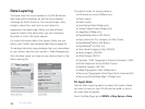
In the lower left corner of the Satellites Page, the GPS
accuracy displays. This is the calculated accuracy of the
GPS, expressed in distance. The actual location is within
plus or minus the distance indicated of the location
represented by the GPS.
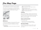
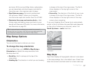
On the Map Page, GPS accuracy is represented by
a circle with a radius equal to the GPS accuracy; your
actual location on the map is within the circle.
Any buildings, natural structures, or heavy foliage that
obstruct the GPS antenna’s view of the sky may prevent
satellite signals from reaching the receiver and decrease
the accuracy of your position. Placing the PN-60 GPS
in a jacket or backpack pocket should not affect
positional accuracy.
Elevation
The elevation is based on the current barometric altimeter
reading. When the Auto Calibrate Altimeter option is
selected, you may see the word “Calibrating” in the
bottom right corner of the screen while the barometer
adjusts—typically 2-3 minutes. If you are using the
Elevation: Barometer info eld on any page, you may
see a red exclamation point in the eld while the
altimeter adjusts.
For more information about calibrating the altimeter,
see Altimeter Calibration on page 87.
Compass and Altimeter
Calibrate the compass and altimeter from the Compass
Page menu or the Satellites Page menu. The Compass
& Altimeter option on the Settings Page has additional
sensor settings. For more information, see Compass
and Altimeter on page 82.
Visit the DeLorme Wiki at wiki.delorme.com for more
information. The latest version of the User Manual is always
available for download.
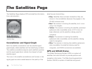
The Satellites Page