


21
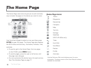
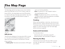
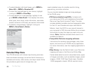
The Map Page centers the map on your current location
when the PN-60 has a 2-D or 3-D x. When it does not
have a GPS x, the map displays your last GPS position,
or, if panning the map, the map cursor position. For more
information, see GPS and WAAS Status on page 18.
GPS Arrow
The GPS arrow displays on the map when GPS is turned
on. The color of the GPS arrow depends on your GPS
signal and the arrow points in the direction of the last
known heading.
Flashing Red–The device cannot obtain a GPS signal
and is not tracking satellites.
Blue–The device is in Track Playback mode or
Simulate Navigation mode.
Yellow–The device has a 2-D x. If a 3-D x has
not been obtained, predicted ephemeris is available.
Green–The device has a 3-D x.
Tracking
When tracking satellites, a track line—also known as a
breadcrumb trail—follows the GPS arrow as you move.
If you have turned off track recording, the track does not
appear. For more information, see The Tracks Page
section starting on page 66.
Scale and Orientation
For information about:
Setting the scale, see Scale on page 28.
Map orientation, see Orientation on page 27.
Panning the Map
There are two ways to pan the map. When you pan
the map, the map cursor—a white arrow—shows
your location.
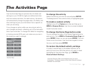
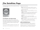
The Map Page
The Map Page