


- 31 -
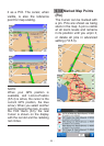
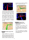
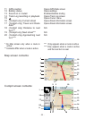
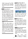
6.5 Screens with Map
Having explained the contents of the map, the description of the other
parts of the map screens follows. There are two map screens: the
Map screen and the Cockpit screen. The way they show the map
is the same but their look and controls are optimized for different
purposes.
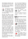
The Map screen is to be used mainly without a GPS, to browse the
map, create user POI items, or to plan your route based on map
points. The Map screen is designed to give you the maximum map
area. This screen is usually used in 2D North-up mode (you can
set this Navigator so it always opens the Map screen like that - see
7.6.1.1).
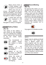
The Cockpit screen is for driving purposes. Besides showing the
map, it contains some additional travel information if you are just
cruising (speed, current street you are driving on, speed limit for the
current street), and additional route data if you are navigating (e.g.
next street in your route, distance to travel, type of the next route
event). This screen is typically used in 3D Track-up mode (you can
make this Navigator always open the Cockpit screen like that - see
7.6.1.2).
There are several controls that function in a similar fashion on the two
screens. They are described on the following pages.
No. Display
1 (Cockpit only) Turn preview*
2
3
4
5
6 Indicates that Follow to GPS
position and heading is inactive
7 Selected map point (Cursor)
8 (Map only) Map scale
9 Menu
10 Map orientation and Overview
Control
Opens Route menu*
Zooms in (optional)
Zooms out (optional)
Tilts down (optional)
Tilts up (optional)
Re-enables Follow-to-Position/Smart
Zoom
Opens Popup Info and Cursor menu
Zooms in/out by dragging
Opens Menu (Find, Quick, Route, Main)
Switches North-up, Track-up and
Overview