


11-11
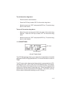
11.7 MAP DATUM/INTERFACE
Database Region
Map Datum
Output Format
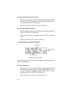
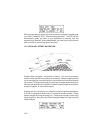
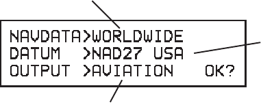
MAP DATUM/INTERFACE PAGE
The Map Datum/Interface Page allows you to select the database region,
map datum, and output data format.
The GPS 100 provides you direct access to a worldwide navigation database.
However, you may reduce the number of duplicate waypoint occurrences
and the size of waypoint scanning lists by selecting a specific region of
operation.
To set the database region...
•
Move the cursor over the database region field and press the CLR key
to select the desired region for database search. You may select
WORLDWIDE or NORTH AMERICA or INTERNATIONAL for the
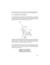
entire database, or AFRICA, CANADA/ALASKA, E EUROPE/CHINA,
EUROPE, LATIN AMERICA, MIDDLE EAST/SOUTH ASIA, PACIFIC,
SOUTH AMERICA, SOUTH PACIFIC, and US CONTINENT (see
Appendix D for a list of the countries associated with each database
region).
The GPS 100 calculates your position based on the WGS-84 map datum. If
your charts (or other electronic devices) are created using a different datum,
you must set the GPS 100 map datum for consistency (a position in the
WGS-84 datum could differ by 1000 feet or more from one calculated using
another datum). Check the datum in the legend of your chart and the
manuals of your other navigation equipment interfaced to the GPS 100.