


4-2
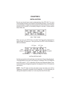
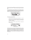
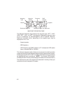
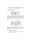
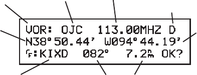
Waypoint Waypoint Frequency DME
Type Name Indicator
Latitude Longitude
Reference Waypoint Bearing & Range from Reference
WAYPOINT DEFINITION PAGE
The Waypoint Definition Page displays the waypoint type (“APT”, “VOR”,
“NDB”, “INT”, “USR”, or “WPT” if no waypoint is displayed), waypoint name
(up to 5 characters), its latitude/longitude, and an optional reference.
Additional information which, depending on the waypoint type, may be
displayed on line 1 are:
· Airport elevation
· NDB frequency
· VOR frequency and DME indicator (a “D” indicates the VOR station
has a co-located DME or TACAN).
The reference waypoint option allows you to compute the relative position
(range and bearing) of the displayed waypoint from a better known location.
If the waypoint type is APT or INT, its nearest VOR station will automatically
be displayed for your convenience. (NOTE: The nearest VOR as deter-
mined by the GPS 100 may not be the approved station due to obstructions.)
The reference for each user waypoint will be stored in memory to help you
remember where the waypoint is located.