


APPENDIX A
GPS — HOW DOES IT WORK?
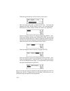
A.1 GPS OVERVIEW
The Global Positioning System (GPS) is a satellite based navigation system
that provides precise position, velocity, and time information. This navigation
system may be used in marine, aviation, and land vehicles, as well as by
hunters, hikers, and military forces.
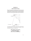
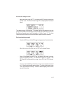
The heart of the Global Positioning System, when complete, will consist of
21 satellites and 3 spares. Circling the earth twice daily, these satellites will
be distributed among six orbits approximately 10,900 nautical miles above
the earth. Each satellite continuously transmits precise timing waveforms
and navigation messages including satellite status, orbital data, and clock
corrections.
The satellite signal is modulated by two high-rate, bi-phase, shifted key
codes: a protected code (P-Code) and an unprotected code (C/A Code). The
P-code is reserved for military use, and the C/A Code is intended for public
access. This signal is extremely resistant to interference from weather,
earth-based radio signals, and electronic equipment.
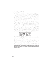
Several ground stations are strategically located to monitor the satellites and
accumulate ranging information from the navigation signals. This information
is processed at the master control station for determination of orbital data
which is then uploaded to the satellites.
A typical GPS receiver consists of an antenna, signal processing electronics,
and processor. The primary function of a receiver is to acquire signals,
recover orbital data, make range and Doppler measurements, and process
this information in real-time to obtain the user position, velocity and time.
A.2 COVERAGE AND ACCURACY
As with Loran-C, the actual accuracy of GPS depends in part on the
geometric relationship between the transmitters (i.e. the satellites) and the
user. Errors in range measurements may result in disproportionately larger
errors in position depending on the geometry of the satellites being used for
navigation.
A-1