


MARINE MODE PAGES AND FEATURES
This section discusses the major pages in Marine Mode, such as
the Map and Compass pages, as well as some additional marine
features, such as DSC and the marine timer.
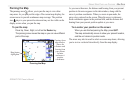
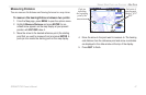
Map Page
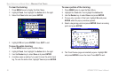
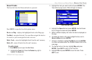
The GPSMAP 276C features a real-time moving map that can do
much more than just plot your course. The Map page displays map
information (digital cartography) that includes navaids, lakes, rivers,
coastlines, cities, and highways. Use the dedicated zoom keys (IN
and OUT) to adjust the Map page scale.
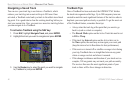
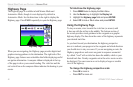
Two basic map operating modes,
position mode and pan mode,
determine what cartography is shown on the map display. Position
mode pans the map to keep your present position in the display area.
The position marker shows your travel on the Map page. The
GPSMAP 276C always powers up in position mode, with the last
known location centered on the map. When you press the Rocker
key, the GPSMAP 276C enters pan mode, which moves the map to
keep the white arrow (map pointer) within the display area.
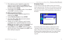
In Marine Mode, by default, four user-selectable data fields appear
on the right side of the screen that can be configured to display any
one of the possible data options. You can also add additional data
fields to the page or select a full screen map without data fields.
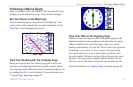
Map Page
Data Fields
Map Scale
Current
Location
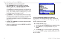
Map Orientation
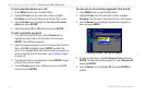
There are two map orientation options: North Up orients the map
like a paper map, while Track Up orients the map in the direction
of travel. When using Track Up, the North arrow indicates the
orientation. To change the map orientation, press MENU to open
the Map page. Press MENU again. Select Set Up Map and press
ENTER. Refer to page 78 for information.
GPSMAP 276C Owner’s Manual 43
MARINE MODE PAGES AND FEATURES > MAP PAGE