


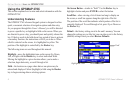

Simulating Navigation
The main purpose of using a GPS receiver is for navigating to a
known position. To get a feel for navigating with the GPSMAP
276C, it is a good idea to practice navigation in Simulator Mode. For
this simulation we have set our location to the San Diego coast.
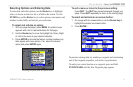
To find a marine destination:
1. Be sure the GPSMAP 276C is set to Simulator Mode (see
“Activating Simulator Mode” on the previous page).
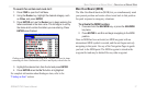
2. Press the FIND key.
3. Highlight Tide Stations and press ENTER.
4. Use the Rocker key to select a nearby Tide Station and
press ENTER. For our example, we selected Point Loma.
5. With Go To highlighted on the Tide Station Information Page,
press ENTER.
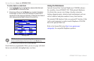
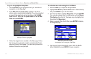
To simulate navigation to the marine destination:
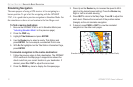
1. Follow the previous steps to find a destination. The GPSMAP
276C switches to the Map page. A magenta line shows the
direct route from your current location to your destination. If
desired, press IN or OUT to adjust the zoom level.
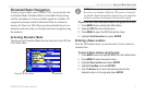
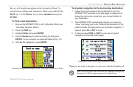
2. Press the PAGE key twice to display the Compass page.
3. Press Up on the
Rocker key to increase the speed to 40 kt.
(which is the desired speed setting). Press the Rocker key
Right or Left to simulate steering.
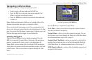
4. Press QUIT to return to the Map Page. Press IN to adjust the
zoom level. Observe the movement of the position marker
(triangle) as the unit simulates navigation.
5. If desired, press PAGE or QUIT to view the simulated
navigation on the other main pages.
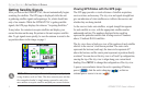
Simulated navigation displayed on the Map Page (Marine Mode)
12 GPSMAP 276C Owner’s Manual
GETTING STARTED > SIMULATED BASIC NAVIGATION