


5
Generally, the position displayed by a GPS receiver using the C/A signals should be accurate to
within 100 feet, and for 50% of the time it should be accurate to within about 40 feet. It is normal for
the displayed position to “wander” slightly over time. For the same reason, the altitude displayed by
a GPS receiver will also vary slightly.
It is important to understand that such variations are inherent in GPS and do not indicate a fault in
the receiver. Remember also, that GPS is operated by the DOD and is subject to military require-
ments. There is no guarantee that signals will always be available, or that any displayed position or
altitude will be accurate.
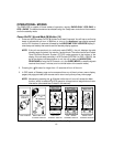
THE GPS RECEIVER
A GPS receiver such as the GMR-GPS uses the C/A signals from the satellites to determine its
position on earth. Signals from three satellites are needed to provide an unambiguous position fix,
with reliable altitude indications requiring a fourth. In most circumstances, a GPS receiver will be
able to receive signals from more than four satellites and can decide which it will use to give the
best position.
Signals from GPS satellites are relatively weak and are easily blocked by obstacles or local screen-
ing. GPS receivers may not work well indoors, in vehicles or underneath trees or foliage. For best
results, the receiver should be able to “see” as much of the sky as possible.
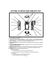
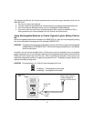
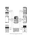
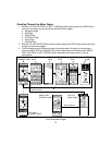
THE GMR-GPS UNIT
The Audiovox GMR-GPS provides you with the features of a precise hand-held GPS unit designed
for general purpose locating and navigation. Not only can it determine your actual position, it can
also guide you to a destination by establishing and storing waypoints to mark the trail or route, and
allow you to return to your original starting point.
But what makes this unit unique, is the incorporation of GMRS capability, whereby your position
can be transmitted to another GMR-GPS unit, thereby allowing another party to know your exact
position, your intended route, and how long it will take you to arrive at that position.
By including three modes of operation, your GMR-GPS can act as a mobile radio transceiver only,
as a GPS unit only or as a combination of the two technologies for navigation and communication
purposes. The GMR-GPS incorporates the following features and capabilities:
• WAYPOINTS: The unit provides 150 waypoints with user-selected names and graphic
symbols.
• ROUTE: Lets you navigate up to 10 routes with 20 waypoints in each route.
• TRACKS: Provides an automatic track log using five saved tracks; these tracks allow
the user to locate the beginning and end point of each track.
• MARK: Allows the user to save and transmit his/her location to other GMR-GPS units
tuned to the same channel (up to a distance of approximately 5 miles).
• GP LOCATOR: Allows the user to receive and store position coordinates of other
GMR-GPS users.