


20
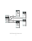
c. TIME ZONE - Selecting the Time Zone provides you with a choice of
the available zones relative to the United States and its possessions.
These consist of ATLANTIC, EASTERN, CENTRAL, MOUNTAIN,
PACIFIC, ALASKA, HAWAII and SAMOA. In addition, Time Zone also
offers a choice of OTHER, whereby the unit can be programmed for
any other specific area not listed. If OTHER is selected, the param-
eters are entered under UTC (Universal Time Clock) Offset. This
provides you with the capability of adjusting the Time Offset value
between +12 and -12 in reference to Greenwich, England.
d. DAYLIGHT (SavingTime) - This menu item provides you with the
capability of choosing the daylight saving time mode (SAVE OFF/
SAVE ON). In either case, the time must be entered manually.
2. Move the wheel key in the up or down position to increase or decrease the volume setting. The
volume bar graph will increase or decrease in steps, accordingly, to a maximum of 16 or a
minimum of 1.
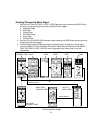
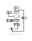
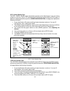
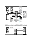
SETTING UP THE GPS FEATURE
Now that the basic setup procedures have been performed, you must now perform the setup proce-
dure for the GPS feature. This is accomplished as follows:
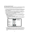
1. From the SETUP display page, select the GPS mode using the Up/Down wheel key; the
GPS icon will be highlighted (boxed). Then press Enter.
2. The GPS menu shown below will appear. The items in this menu are accessed and edited in
the same manner as explained previously for the SETUP menu; use the Up/Down/Enter
wheel key switch as before.
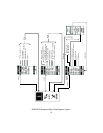
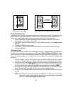
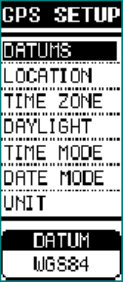
a. DATUMS - Since maps and charts are created using a starting reference point called a
datum, this starting point will differ from map-to-map. The most common mathemati
cal ellipsoid used is WGS-84 (World Geodetic System 1984). In addition to the WGS-84
standard, a great many other datums are available for entry depending on user location.
If you use maps or charts specifying a datum other than WGS-84, you should change
the datum applicable to that region to reduce position errors. If you are not sure of which
datum to apply, use the WGS-84 datum for best overall performance.
b. LOCATION - The Location item provides you with four choices for display of positional
information; namely, Degrees (DDD°), Minutes (MM’), Seconds (SS”), Degrees and
Minutes only (DDD°MM.MM’), Degrees only (DDD.DDDDD°) or a UTM (Universal
Transverse Mercator). The capability to adjust the time offset value is available under
the OTHER option of the TIME ZONE function below.
e. TIME MODE - Selecting the Time Mode item allows you to select the way the time is
presented on the display (either 12 HOURS or 24 HOURS clock format).
f. DATE MODE - Selecting the Date Mode item allows you to select the way the date is
presented on the display (DD-MM-YY, MM-DD-YY, or YY-MM-DD), where M=month,
D=day and Y=year.
g. UNIT - This item allows you to specify distance measurements in METRIC
(Meters/Kilometers), STATUTE (Feet/Miles) or NAUTICAL units.