4
GENERAL FEATURES
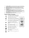
GPS FEATURES
- 128 x 64 Dot Pixel LCD Display
- LCD Backlight for Night Operation
- Mode Icons for GPS + RADIO, GPS ONLY and RADIO ONLY
- 8 Parallel Channel Satellite Receiver
- GPS Partner Locator (GP LOCATOR)
- Stores 10 Routes with Up to 20 Waypoints Each
- Provides 5 Tracks
- Map and Pointer Displays Provide:
Latitude and Longitude
Current/Average/Maximum Speed
Bearing and Heading
Date and Time
Sunrise and Sunset
GMRS FEATURES
-
15 GMRS Channels (7 Shared FRS)
- 38 Privacy Codes (For Each Main Channel)
- Built-In Hands-Free VOX Capability
- Up to 5-Mile Range
GENERAL FEATURES
-
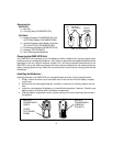
Requires 4 AA Alkaline Batteries or Type NiMH or other type
Rechargeable Batteries (Not Included)
- Fold-Down GMRS Antenna
- Swivel Belt Clip
THE GLOBAL POSITIONING SYSTEM (GPS) NETWORK
GPS is a world-wide radio navigation system based on a group of about 26 satellites and their
associated ground stations. A GPS receiver uses signals from the satellites to calculate its position
and altitude. The basis of GPS operation is triangulation, and the receiver uses the travel time of
radio signals from the satellites to calculate its distance from each one using a technique called
“pseudoranging”. It can then create lines of position.
The satellites transmit two types of signals called “C/A” (coarse/acquisition) and “P” (precision). The
latter are encrypted and can only be used by military GPS receivers. As with all other GPS units
available to the public, the GMR-GPS makes use of the C/A signals to establish position and
altitude. The accuracy of a displayed position varies with a number of factors including time.


