


5700 GPS Receiver User Guide 97
Real-Time Kinematic (RTK) Surveying 8
Applications
Reference station coordinate accuracy
Incorrect or inaccurate reference station coordinates degrade the rover
position solution. It is estimated that every 10 meters of error in the
reference station coordinates introduces one part per million error in
the baseline vector. This means that if the reference station coordinates
have a height error of 50 meters, and the baseline vector is
10 kilometers, then the error in the rover location is approximately
five centimeters. For optimal results, the reference station coordinates
should be known to within 10 meters in the WGS-84 datum.
Number of visible satellites
The more GPS satellites that are visible, the greater the solution
quality and integrity. Even though only four satellites are needed to
calculate a three-dimensional position, RTK initialization requires that
at least five common satellites be tracked at the reference and rover
sites. In addition, L1 and L2 carrier phase data must be tracked on the
five common satellites for successful RTK initialization.
Elevation mask
Because atmospheric errors and signal multipath are largest for low
elevation satellites, the elevation mask stops the 5700 receiver from
using satellites that are low on the horizon. The 5700 receiver uses a
default elevation mask of 13 degrees. If a lower elevation mask is
used, system performance is degraded.
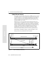
Operating range
Operating range refers to the maximum separation between reference
and rover sites. Often the characteristics of the data link determine the
RTK operating range.
Although a shorter baseline will improve solution reliability, the 5700
receiver can remove ionospheric and tropospheric bias to allow
reliable operation on baselines beyond 10 km.