


Chapter 4: Further Chart Operations 4-1
Introduction
Chapter 4: Further Chart Operations
4.1 Introduction
This chapter explains how to usethe additional functions that are provided on
the chartplotter display.
It covers the following topics:
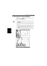
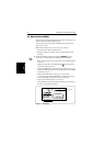
• Measuring distances and bearings on the chart, using the VRM/EBL key
• Setting alarms and timers
• Man Overboard (MOB)
• Cursor Echo
• GPS Setup
• Data Log Mode
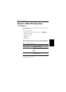
In orderto usesome ofthese functions, youmay need thefollowing additional
data from equipment connected to your system via a SeaTalk or NMEA link:
*If heading data is available via both NMEA and SeaTalk, NMEA data takes priority. For all other data,
SeaTalk data takes priority (see Section 4.3).
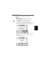
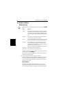
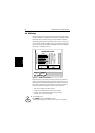
Table 4-1: Function of External Data
Data Example source Integrated functions available
Heading
COG
Compass*
GPS
- Head Up or Course Up heading modes
- MOB (if speed data also available)
Position GPS system - Waypoints
- Position, COG, SOG and time data in Data Box and Nav
Window
- MOB
- Data Log
Other data Transducers - Data Box and Nav Window data displays, including speed,
depth, wind, temperature