


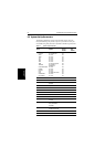


5-12 SL520/530/631 PLUS Chartplotter Displays
Plotter Mode
• chart boundaries (on,off,custom)
• spot soundings (on, off, custom)
• depth shading limit (set the limit)
• depth contours (on,off,custom)
• depth contour display (set the upper and lower limits)
• nav marks (on,off,custom)
• nav marks icon (international,US)
• light sectors (on, off, custom)
• caution and routing data (on, off,custom)
• marine features (on, off, custom)
• land features (on,off,custom)
• icon display (simple, detailed,custom)
The factory default for CUSTOM options is ON.
Plotter Mode
PlotterMode enables youto zoom into asmaller area, even when nochart data
is available for that scale. This allows you use the chartplotter functions at
large scales even when a chart card is not installed.
Chart Orientation
The chart orientation is normally North Up, but can be changed to Course Up
or Head Up if heading data is available. The orientation modes give the
following displays:
• North Up: The chart is displayed with north upwards. As you change
heading, theship’s heading marker moves. This is the default mode, and is
the only mode available if there is no heading data.
• Course Up: The chart is stabilized and displayed with the currently
selected course upwards. If you select a new course, the picture rotates to
display the new course upwards.
The reference used for the Course Up depends on the information avail-
able. The first available in the following is used:
i. A locked heading over a SeaTalk connection
ii. The heading at the time Course Up was selected
To update the Course Up reference while Course Up is the current mode,
re-select Course Up from the set up menu.
• Head Up: The chart is displayed with the vessel’s current heading
upwards. As the heading changes the chart will rotate.