


Chapter 1: Overview 1-5
The Chartplotter
Display
The Chartplotter
Display
1.2 The Chartplotter Display
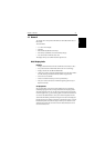
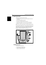
The SL520/530/631 PLUS display includes a Chartplotter. The chartplotter
includes a small-scale world map and detailed navigation information is
displayed when a cartographic chart card is installed. The details displayed
depend on the chart zoom level selected. A plotter mode is provided toenable
route plotting and tracking at large scales even when a chart card is not
installed, or when the chart is zoomed beyond the available cartographic
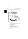
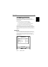
detail. A typical chartplotter screen is shown in Figure 1-1.
The chartplotter uses position information from a GPS, DGPS, WAAS or
Loran-C instrument. Once the position fix has been established, your vessel’s
position, if on screen, is shown as a boat shape pointing in the direction of the
current heading (or COG if heading data is not available). If no heading or
COG data is available, the vessel is shown as a circle.
The chartplotter screen includes a status bar that displays chart scale, with
either cursor position, range and bearing or, when the cursor is homed to the
vessel (by pressing FIND SHIP), vessel position, Speed Over Ground (SOG),
Course Over Ground (COG) and fix type (VES POS, DIF FIX or SD FIX).
Any waypoints you have placed are displayed (unless you turned them off in
Chart Set Up as described in Chapter 5) and the current route is shown.
Information can be viewed on-screen by positioning the cursor over a
waypoint, current route or chart object. The chartplotter screen can also show
additional information, depending on your currently selected options, set up
selections and data available from other equipment.
An example chart display, in its default configuration, with a chart card
installed, is shown in the following illustration.
Several functions are available to control the display as follows:
• Zoom in/out and Pan the Display
• Offset the Chart or Center the Chart around the Vessel
Operation of these functions is described in Chapter 2.
Chartplotter Display Options
In addition to the display set up options previously described, chart set up
options,described inChapter 5, allow youto customize the chartby selecting:
• What cartographic features and level of detail are displayed.
• The chart color palette (sunlight or shade) - color displays only.
• Chart orientation (north up, head up or course up), datums and position offset.
• How waypoints are displayed (symbols and numbers) and the availability
of chart object identification data.
• Vectors for heading, COG and tide.