


3-2 SL520/530/631 PLUS Chartplotter Displays
Using Chart Cards
3.2 Using Chart Cards
The chartplotter has a built-in world map; most areas are displayed on a scale of
4000 nm from the top to the bottom of the screen, and can be zoomed in to
150 nm.
To usethechartplotter asa navigation aid,charts withdetailed information forthe
area you wish to navigate are required. The charts are available on C-MAP NT
electronic chart cards (C-Cards), each of which can store as many as 20 charts in
an electronic format. A single C-MAP chart normally provides as much
information as is available in paper charts for that geographic area, and can be
displayed down to a range of 1/64 nm on the screen if the data is available.
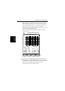
Two card slots are provided on the display unit. Chart data from both slots can
be downloaded.
The chart scale in use is indicated in the status bar - the number represents the
distance (in nautical miles) displayed from the top of the chart window to the
bottom of the chart window.
Note: You can remove and insert cards while a chart is displayed. The chart
information is retained on-screen until the chartplotter redraws the screen:
for example, when you pan outside the current area, or use the RANGE key to
change the chart scale.
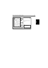
Inserting a Chart Card
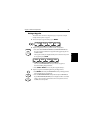
➤ To insert a chart card:
1. Check that the card is a C-MAP NT C-Card with the required chart stored
on it.
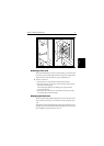
2. Open the card cover, at the lower left of the display front panel.
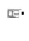
3. Hold the card with the title label towards the left, as shown in the illustra-
tion.
4. Gently push the card into one of the two slots. It will only go in if it is cor-
rectly oriented. Push the card in as far as it will go, then move it to the right
so that the top is underthe retaining pegs. The card will be held in place by
the pegs.
5. Close the card cover until it clicks shut, to prevent water entering the dis-
play unit.