


User’s manual NAVIGON 92 Plus | 92 Premium
- 54 - Working with the map
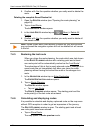
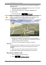
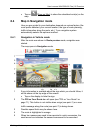
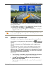
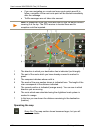
1 When the MyRoutes function is activated, up to three numbered routes
are indicated on the map in different colours (orange, green, blue).
In the following cases only one route is shown:
► The MyRoutes function is deactivated (see "MyRoutes" on
page 39).
► You have planned a route with more than one route point.
► A route profile with the Pedestrian speed profile is active.
2 The destination is marked with a little flag.
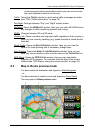
If you display a planned or loaded route, the starting point and each
route point will be marked with a little flag.
In the case of a multi-leg route, the distance and the estimated driving
time for each leg are displayed.
3 The current position is indicated (orange arrow).
If you display a planned or loaded route and the specified starting point
is not your current location, then it is possible that your current position
will not be shown on the preview.
4 The current route profile is indicated on the (Route Profile) button.
The symbol illustrates the mode of transport on which the profile is
based (see "Route Profiles" on page 65).
► Tap on the symbol to select a different route profile.
5 For each route (orange, green, blue) there is a button with the same
number and a symbol in the same colour. Indicated on each button are
the estimated time of arrival, the total distance and the estimated
duration of the particular route.
If traffic messages exist for a route and the value On Request is
selected for the Route Optimisation setting, the number of messages
will be indicated in a small traffic sign on the button. The reported
obstructions are also indicated on the route.
The route which corresponds best to the selected route profile is
marked with "MyRoute".
If the MyRoutes function is not activated, only one route is presented.
As soon as you tap on a button, navigation along the route in question
will start.
► Tap on the (Route Profile) button (see figure, point 4) in order
to select a different route profile.
► To start the navigation, tap on the button for the route (see figure,
point
5) you want to use for the navigation.
If you display a planned or loaded route, the route may be
recalculated. The starting point for the calculation will now be your
current location. You will first be guided to the first route point
entered.