


User’s manual NAVIGON 92 Plus | 92 Premium
Navigation - 49 -
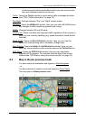
The starting point and the route points are marked by flags. The
distance and the estimated trip time is given for each leg of the
route.
7.4.7 Simulating routes
It is also possible simply to simulate navigation on a planned route.
Note: GPS reception is not necessary for simulation.
If you have planned a multi-leg route, only the first leg will be simulated.
Note: When simulation is in progress, the symbol will appear
instead of the GPS symbol (see "GPS" on page 18).
You have calculated and displayed a route. The map is open in Route
preview mode.
1. Tap on (More) > Simulation.
► If you have planned a route with only one route point and the
MyRoutes function is activated, you will be prompted to select
a route for the simulation.
The route will be recalculated for simulation purposes.
2. Tap on the button of the route on which you want to simulate the
navigation.
For more details about the MyRoutes function refer to the chapter
"MyRoutes" on page 50.
Stopping simulation
Simulation is ended in the same way as navigation:
1. Tap on the map to open the button bar.
2. In the button bar tap on (Navigation Options) or
(Navigation).
3. Tap on the Stop Simulation button at the top left edge of the screen.
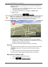
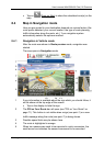
7.4.8 Route preview
You have calculated and displayed a route. The map is open in Route
preview mode.
The navigation destination is depicted by a small flag.
For detailed information refer to the chapter "Map in Route preview
mode" on page 53.