


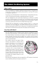


79
Glossary
Active Leg The segment of a route currently being travelled.
Azimuth The angular measurement from the horizon to a satellite
or other object.
Backtrack Retraces the position fixes (up to 21) stored automatically
by the receiver every 10 minutes.
Bearing The compass direction from your position to a destination,
measured to the nearest degree.
Coordinates A unique numeric or alphanumeric description of position.
Course The direction in degrees from the start waypoint of a
course line to its destination.
CTS The optimum direction the vessel should be steered in order
to efficiently make headway back to the courseline while
also proceeding toward the destination waypoint. It is a “com-
promise” course bearing that projects from your current
position to a point on the courseline mid-way between a
point perpendicular to your position and the current leg des-
tination waypoint.
Datum Refers to the theoretical mathematical model of the earth’s
sea level surface. Map makers may use a different model
to chart their maps from so positions will differ from one
datum to another. The datum for the map you are using
can be found in the legend of the map.
Elevation Distance above or below mean sea level.
EPE Estimated Position Error is the approximate error (between
0 and X) introduced in the ephemeris signal by the U.S.
Department of Defense for reasons of security. This
random error, known as Selective Availability (SA) is not
due to receiver error and is not significant enough to affect
navigation for most purposes (See DGPS in appendix).
ETA Estimated Time to Arrival is the approximate time it will take
to reach the destination from the current position based on
VMG.
Geometric Measures the probable accuracy of a position fix, based on
Quality the position of the satellites relative to each other.