


75
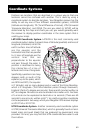
The Global Positioning System
What Is GPS?
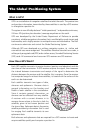
GPS is a constellation of navigation satellites that orbit the earth. The precise time
and position information transmitted by these satellites is used by a GPS receiver
to triangulate a position fix.
The system is now officially declared “initial operational,” and provides continuous,
24-hour 3D (position plus elevation) coverage anywhere on the earth.
GPS was developed by the United States Department of Defense to provide
consistent, reliable navigation information that is unaffected by rough terrain and
bad weather, and is highly resistant to multipath errors and interference. The DoD
continues to administer and control the Global Positioning System.
Although GPS was developed as a military navigation system, its civilian and
commercial uses were recognized. The satellites therefore transmit two codes, a
military-only encrypted code (PPS) and a civilian-access, Standard Positioning Service
(SPS) code. All commercial and consumer GPS receivers are SPS receivers.
How Does GPS Work?
Each GPS satellite transmits its precise location (position and elevation) and the
start time of the transmission. A GPS receiver acquires the signal, then measures
the interval between transmission and receipt of the signal to determine the
distance between the receiver and the satellite: this is ranging. Once the receiver
has computed range for at least three satellites, its location on the surface of the
earth can be determined.
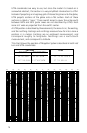
Each satellite transmits two types of data,
almanac and ephemeris. Almanac data is
general information on the location and
health of each satellite in the constellation.
Since it contains general information, an
almanac can be collected from any satellite.
A receiver with a current almanac in its
memory knows where in the sky to look for
satellites, given its last known position and
the time of day. Ephemeris data is the precise
satellite positioning information that is used
for ranging. Each satellite transmits its own
ephemeris data.
Both almanac and ephemeris data are required for a GPS receiver to locate and
acquire satellites quickly and compute a position fix.
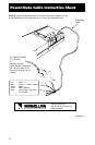
E
Q
U
A
T
O
R
0
°
P
R
I
M
E
M
E
R
I
D
I
A
N
0
°
L
a
t
i
t
u
d
e
L
o
n
g
i
t
u
d
e
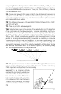
115
°00.00W
4
2°30
.0
0N