


43
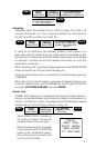
Setting the Coordinate System
The coordinate system you ultimately select will depend on the maps
or charts that you are using with your receiver. The default coordinate
system is LAT/LON, DEG/MIN.00.
If you select LAT/LON, you will be asked to select one of three
formats for displaying position coordinates: DEG/MIN.00, DEG/
MIN.000 or DEG/MIN/SEC. If you choose one of the first two
options, the display is in decimal format, while the third option is
based on 60 seconds in a minute.
Available Coordinate Systems:
LAT/LON OSGB SWEDISH GRID
UTM IRISH GRID FINNISH GRID
TD SWISS GRID
Setting the Elevation Mode
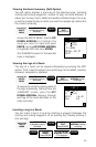
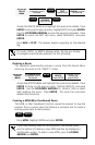
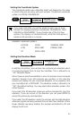
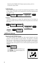
MENU
Highlight
SETUP
Press ENTER
Highlight
COORD SYS
Press ENTER
Use UP/DOWN
ARROWS to select
coordinate system
ENTER
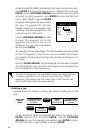
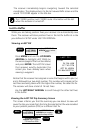
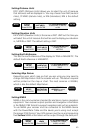
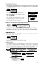
MENU
Highlight
SETUP
Press ENTER
Highlight
ELEV MODE
Press ENTER
Use UP/DOWN
ARROWS to select
2D or 3D
ENTER
In addition to position, your receiver can compute your elevation when
it is receiving signals from at least four satellites. This is referred to as
“3D” Elevation Mode.
When there are only three satellites in view, the receiver cannot compute
elevation though it can still compute your position. In this case the
receiver will display the last computed elevation or the elevation that
you manually enter in INITIALIZE. This elevation mode is referred to as
“2D” (the default setting). You may select either elevation mode in this
SETUP feature.
If you select the 2D elevation mode you will be prompted to input the
elevation. If you are unsure of the elevation you can press ENTER to
accept the previously used elevation.
If you select the 3D elevation mode, the receiver will calculate elevation
whenever signals are being received from at least four satellites. When
fewer satellites are being tracked, the receiver will default to 2D and
display the 2D icon.