


70
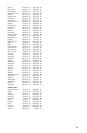
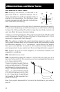
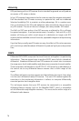
UTM coordinates are easy to use, but since the model it is based on is
somewhat abstract, this section is a very simplified introduction to UTM.
Instead of projecting an imaginary grid of intersecting lines onto the globe,
UTM projects sections of the globe onto a flat surface. Each of these
sections is called a “zone.” There are 60 zones to cover the entire earth
between 84˚N and 80˚S (polar areas are not described by UTM). Each
zone is 6˚ wide as projected from the earth’s center.
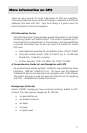
A UTM position is described by three elements; the zone it is in, the easting,
and the northing. Eastings and northings measure how far into a zone a
position is in meters. Eastings are an east/west measurement, and
correspond roughly to longitude. Northings are a north/south
measurement, and correspond to latitude.
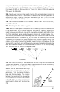
This chart shows the position of Magellan Systems described in both Lat/
Lon and UTM coordinates.
LAT/LON UTM
DEG/MIN DEG/MIN/SEC
34˚06.58N 34˚06’35"N 11 4 23 818 E
117˚49.56W 117˚49’34"W 37 74 624 N
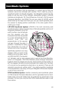
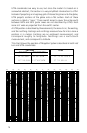
15111213 14
3000 Km
3000 Mi.
Scale at the Equator.
12345
180°
150°
10
120° 90°
20
60°
25
30°
30
0°
35
30°
40
60°
45
90°
50
120°
55
150°
60
180°
0°
NOTE: The area described by the UTM coordinate system extends to 84°N and to 80°S.
6789 16171819 21222324 26272829 31323334 36373839 41424344 46474849 51525354 56575859