


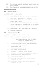
61
GLL Geographic Position — Latitude/Longitude
1 2 3 4 5 6
GLL,1111.11,a,yyyyy.yy,a,hhmmss.ss,A*hh
1-2 Latitude, N/S
2-3 Longitude, E/W
4 UTC of position
6 Status A = Data valid
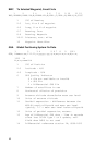
RMB Generic Navigation Information (immediately follows RMC)
1 2 3 4 5 6 7 8 9 10 11 12
RMB,A,X.XX,L,CCCC,CCCC,SSS.SS,N,XXXXX.XX,W,XXX.X,XXX.,XX.X,
13 14
A *XX
1 Status (A = valid, V = invalid)
2-3 XTE, naut. miles and direction to steer (L or
R) [If XTE exceeds 9.99 NM, display 9.99 in
field 2.]
4 Origin waypoint ID
5 Destination waypoint ID
6-7 Destination Waypoint Latitude (N or S)
8-9 Destination Waypoint Longitude (E or W)
10 Range naut. miles, present fix to destination
waypoint Great Circle. [If range exceeds
999.9 nm, display 999.9.]
11 Bearing, True, Great Circle, Present fix to
dest. waypoint
12 Closing velocity to destination, knots
13 Arrival (OR’ed arrival circle and crossing of
line which is perpendicular to the course line
and which passes through the destination
waypoint.)
14 CHECKSUM (Mandatory in this sentence.)