


26
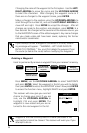
Creating a Waypoints
This allows you to create and store a waypoint with a receiver-generated
name or a user-assigned name and allows you to assign the position
coordinates.
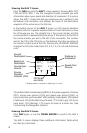
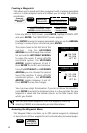
From any NAV or PLOT screen, press ENTER, highlight CREATE WPT
and press ENTER. The CREATE WPT screen appears.
Press ENTER to accept a receiver-generated name or use the ARROWs
to assign a name of your choice and press ENTER.
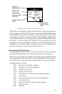
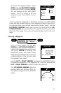
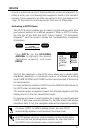
The cursor moves to the first line of the
position. Use the UP/DOWN
ARROWs to scroll through the number
list, and use the LEFT/RIGHT ARROWs
to move the cursor. If using LAT/LON
coordinate system, the UP/DOWN
ARROW toggles between N and S.
Press ENTER to confirm and continue.
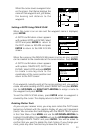
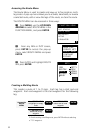
Using the LEFT/RIGHT and UP/DOWN
ARROWs you can change the second
line of the position. If using LAT/LON
coordinate system , the UP/DOWN
ARROW toggles between E and W.
Press ENTER to save the changes.
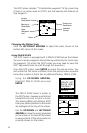
CREATE POS
JETTY
34`06.58N
117`49.56W
0FT EL
CREATE POS
JETTY
34`12.45N
117`49.56W
0FT EL
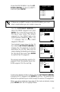
You may now assign the elevation. If you do not know the elevation,
press ENTER to accept the displayed value. In a few seconds the new
waypoint is saved and the receiver returns to the NAV screen from
which you started.
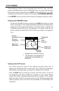
You can also create waypoints from the waypoint menu by
selecting CREATE and proceeding as described above.
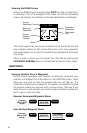
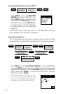
Accessing the Waypoint Menu
The Waypoint Menu contains up to 200 named waypoints, displayed
in two columns of four waypoints each and extending to several pages.
MENU
Highlight
WAYPOINTS
Press ENTER
Use ARROW KEYS to
assign icon and name
ENTER
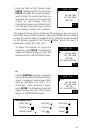
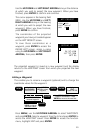
From any
NAV or PLOT
Screen
Highlight
CREATE WPT
Press ENTER
ENTER
optional:
Use ARROW KEYS to assign
position coordinates. Press
ENTER to move to the next line.
Use ARROW
KEYS to assign
elevation value.
ENTER