


22
The PLOT screen displays “TO destination waypoint” of the current leg
if there is an active route or GOTO, and the bearing and distance to
that waypoint.
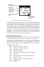
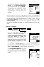
Changing the Plotter Scale
Press the LEFT/RIGHT ARROWS to adjust the scale, shown at the
bottom left corner of the screen.
Using PAN N SCAN
The PLOT screen is equipped with a PAN N SCAN feature that allows
the user to access waypoint information by positioning the cursor over
the waypoint. (To access the PLOT screen you may need to press the
PLOT key several times to scroll through the sequence.)
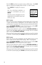
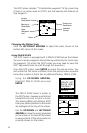
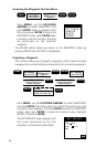
From the PLOT screen, press ENTER to access the pop-up menu. You
will notice that this menu is different from the pop-up menu accessed
from other screens in that it has an additional feature, PAN N SCAN.
Using the UP/DOWN ARROWs,
highlight PAN N SCAN and press
ENTER.
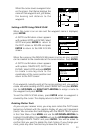
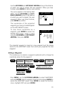
n
m
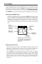
PAN N SCAN
BRG
DST13.5
028`
M
25
n
m
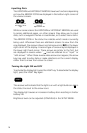
The PAN N SCAN screen is similar to
the PLOT screen, however a vertical and
horizontal line cross to form a cursor.
The bearing (BRG) and distance (DST)
from your present position to the cursor
are displayed at the top of the screen.
Use the UP/DOWN and LEFT/RIGHT
ARROWs to move the cursor anywhere
on the screen or to scroll off the screen
to view portions of the active route not
currently shown on the screen.
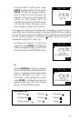
n
m
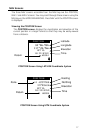
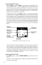
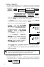
TO JETTY
BRG
DST13.5
Current
Destination
Bearing to
Destination
Distance to
Destination
Scale
028`
M
25
n
m
Near
Waypoint
Icon
Intended
Course
SAVE POS
CREATE WPT
ROUTE MENU
CONTRAST
PAN N SCAN
ESCAPE