


71
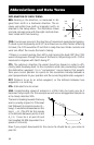
TD Coordinate System. TDs are indicated on many nautical charts in
addition to the LAT/LON marks. They are established lines of position
(LOPs) that are determined by the difference in the length of time required
to receive Loran-C signals. Many coastal navigators use TDs because Loran
is a familiar radio aid navigation and TDs are clearly marked on their charts.
The Meridian XL can display position coordinates in TDs by converting
from position fixes calculated in Lat/Lon. (No measurements are made
using the Loran signals.)
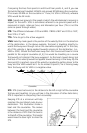
To use TDs, the Loran receiver is set to a specific chain of stations; each
Loran chain consists of one master station (designated as M) and two or
more secondary stations (W, X, Y, and Z). Next, the navigator determines
which two secondary stations will provide the most accurate position fix
based on the angle of intersection of the LOPs. The TD measurement is
the difference between the time it takes a signal to arrive from the master
station and the time it takes to arrive from a secondary station to your
location. This is referred to as a TD. Two TDs are required for a position
fix.
The Meridian XL displays position coordinates in TDs by converting the
LAT/LON coordinates to TDs, mathematically, using the GRI (chain number)
and secondary beacons you entered when selecting the TD coordinate
system.
When TD is selected in Setup under COORD SYS you will be asked to
select the following
1) The GRI (also called the chain) that you will be navigating in.
2) The two secondary stations that will provide you with the best
angle of LOP intersections. If you have used Loran in the past, you
should simply enter the values that you have used before.
Other Coordinate Systems. OSGB coordinates are similar to UTMs, but
they describe only Great Britain. They must be used with the GBR36 datum,
which also describes Great Britain. This coordinate system cannot be used
in any other part of the world. The Meridian XL automatically selects the
GBR36 datum when the OSGB coordinate system is selected in Setup.
(While OSGB coordinates must be used with the GBR36 datum, the GBR36
datum can be used with LAT/LON coordinates; just be sure the map you
are using uses both LAT/LON and GBR36.)
If you select OSGB in the COORD. SYS. portion of the Setup
Menu be sure to change the map datum back to the one you
will be using (WGS84 is the default) when changing to another
coordinate system.
Irish Grid uses the Ireland datum, Swedish Grid uses the RT90 datum,
Swiss Grid uses the Swiss datum and Finnish Grid uses KKJ datum.