


6
If you inadvertently press another key without initializing manually, the
receiver displays the POSITION screen with null values for the latitude
and longitude (00°00.00N, 000°00.00W). In this case, the receiver will
self-initialize, which may take 15 minutes or more. The elevation mode
will automatically switch from 2D to 3D, which is necessary to obtain a
proper first fix. The recommended method is to press ENTER and
initialize manually, which will allow the receiver to get a position fix
sooner.
Using latitude and longitude will satisfy most of the users of this
receiver, but you may use any of the other coordinate systems
(UTM, OSGB, TDs, Irish Grid, Swiss Grid, Swedish Grid or Finnish
Grid) to initialize the receiver. If you prefer one of these coordi-
nate systems, select the desired coordinate system in the
COORD. SYSTEM section of Setup, then access INITIALIZE. You
will be prompted to enter the appropriate data in the format of
the chosen coordinate system.
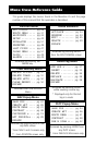
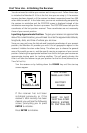
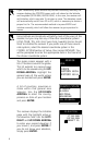
The region screen appears with a
list of locations around the globe.
This list extends to a second page
which can be viewed using the UP/
DOWN ARROWs. Highlight the
general area of the world where
you are located and press ENTER.
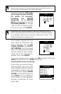
A list of countries, provinces or
states within that general area
appears. Use the UP/DOWN
ARROWs to select the country,
province or state of your location
and press ENTER.
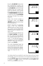
The receiver displays the Initialize
page with the highlight active in
the elevation field. Use the LEFT/
RIGHT and UP/DOWN ARROWs
to enter your present elevation if
you know it, and press ENTER. If
you do not know your elevation,
simply press ENTER.
ELEVATION
37`00.00N
119`00.00W
+00000FT EL
COUNTRY/STATE
ALABAMA
ALASKA
ARIZONA
ARKANSAS
CALIFORNIA
REGION
USA
THE AMERICAS
EUROPE
EASTERN ASIA
WESTERM ASiA