


24
Viewing the ROAD Screen
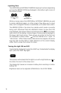
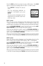
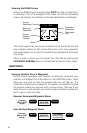
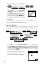
Access the ROAD screen by pressing the PLOT key (two or three times,
if necessary). This is the navigation CDI screen. As with the preceding
screen, the bearing and distance to the leg destination are displayed.
n
m
TO JETTY
BRG
DST13.5028`
M
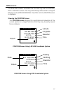
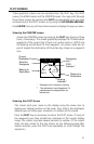
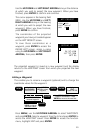
25
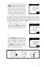
n
m
Scale
Current
Destination
Bearing to
Destination
Distance to
Destination
Destination
Icon
Course
Deviation
Indicator
This screen depicts the course you should be on as the center line and
your position relative to the course (the arrow icon). Any waypoints
that would appear on or near this courseline are displayed as they come
into range.
When a route is active, you can adjust the CDI scale by pressing the
LEFT/RIGHT ARROWs shown in the bottom left corner of the screen.
WAYPOINTS
Saving a Position Fix as a Waypoint
During normal operation your receiver continuously computes your
position and displays that information on the POSITION screen. Quite
often you will want to store the position data for use later on. This
stored fix is referred to as a waypoint. An obvious use would be to store
the position where you are now with a unique name. That way if you
were to go to a new location you could use your receiver to guide you
back to your current location.
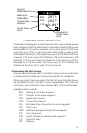
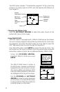
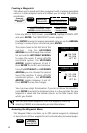
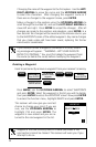
Receiver Generated Waypoint Name
ENTER
From any
NAV or PLOT
Screen
Highlight
SAVE POS
Press ENTER
ENTER
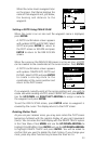
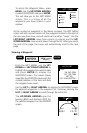
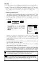
User Defined Waypoint Name
ENTER
From any
NAV or PLOT
Screen
Highlight
SAVE POS
Press ENTER
ENTER
Use ARROW
KEYS to assign
icon and name