


74
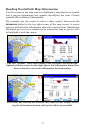
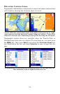
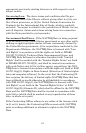
Elevation Contour Lines
Topographic information is displayed as major and minor contour lines
with numbers showing the elevation above sea level.
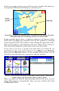
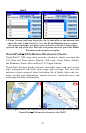
At left, different colors mark parks and public hunting areas. At right,
topo contours and the border of a game refuge are shown. Cursor has
selected a contour line, launching a pop-up box showing the elevation.
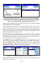
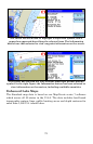
Topographic contour lines are available when the Turn-by-Turn or
Standard map data sets are selected. To turn them on, you must press
the
MENU key, then press MENU 2 and select the CATEGORIES DRAWN but-
ton. Scroll down the list and check
ELEVATION to turn on topo line dis-
play.
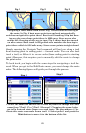
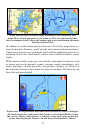
You must turn on Elevation in Categories Drawn to see topo lines. At
left, elevation is off; at right the feature is on.