


2
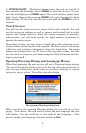
How Lowrance GPS and the GPS System Work
You will navigate a little easier if you understand the basics of how the
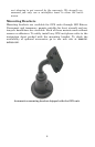
iWAY scans the sky to show you where you are and where you are go-
ing. You will use the iWAY's touch screen and buttons to enter com-
mands and control its functions.
As long as there is no interference − and the unit is locked on to a satel-
lite signal − it will display your location on a moving map and help
guide you to your destination. The power cord speaker allows you to
hear verbal turn-by-turn driving instructions and listen to MP3 music
files.
The internal antenna tunes in to a couple of dozen GPS (Global Posi-
tioning System) and WAAS satellites circling the earth. The unit lis-
tens to signals from as many satellites as it can "see" above the horizon
then computes its location in relation to those satellites. The iWAY
plots your position on the map display on-screen.
For the system to work the unit must have a clear view of the satellites.
Unlike radio or television signals, GPS works at very high frequencies.
These signals can be easily blocked by trees, buildings, an automobile
roof, even your body.
The iWAY's hard drive contains highly detailed road and highway
mapping data for Hawaii, Alaska, the 48 contiguous United States and
most of Canada.
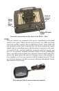
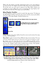
The iWAY 600c is the world's first portable navigation device with sat-
ellite imagery in full color. It's also the first automotive GPS to contain
color satellite photos. This unit contains photos for more than 150 of
the largest metropolitan areas in the United States and Canada.
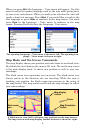
When you're in an area covered by satellite photography, you can tog-
gle the map display between road map view, satellite view or satellite
view with map overlay. This function is controlled by the Map View
button on the Map Display Toolbar.
If you would like to know more about GPS and its companion system
WAAS, visit our web site and check out the GPS Product Guide section
(www.lowrance.com/Support/gps.asp). It includes a GPS tutorial, fre-
quently asked questions and a glossary.