


66
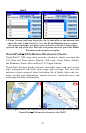
Course: The direction you should be traveling to reach your destina-
tion when you are on the original course line.
Off Course (Pos Error): The distance (to the left or to the right) from
the course line.
Steer so your Track, Bearing and Course match, and you will be headed
straight for your destination along your original course.
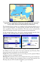
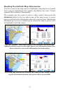
Navigating With Trails
Displaying and editing trails are discussed earlier in this manual un-
der the topics Categories Drawn and My Trails. The following instruc-
tions will show you how to navigate with trails.
The Trails feature is always turned on in this unit, and it works in both
point-to-point and turn-by-turn modes. However, trails are especially
useful in off-road or marine situations. They help you retrace your
steps where no roads exist for reference.
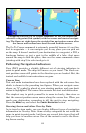
A trail, or plot trail, is a history of the path you have taken. This travel
history is represented by a line extending from the back of the current
position arrow. As you move, the unit draws this line by recording or plot-
ting a string of trail points along your path. The iWAY's built-in memory
can save 100 trails, with up to 10,000 points recorded per trail. (The de-
fault setting is 2,000 points per trail.) When trail length exceeds the
maximum point setting, the iWAY will begin recording a trail over itself.
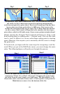
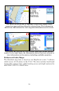
You can save a set of up to 100 trails in a GPS data file (*.usr file for-
mat) on the unit's hard drive. The trails can then be deleted from the
unit's memory and you can record a new set of trails to save in another
GPS data file. With a USB connection, these GPS data files can also be
backed up on a computer hard drive.
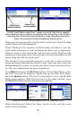
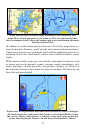
NOTE:
GPS data files, also referred to as "user files," can contain trails,
routes and the waypoints (contacts) in your Address Book. Maxi-
mum capacity per file is 1,000 waypoints, 100 routes and 100 trails.
These files can by opened by our MapCreate custom mapping soft-
ware, or by our GPS Data Manager program. These programs allow
you to view and edit GPS data on the computer screen. The GPS
Data Manager can be downloaded free from
www.lowrance.com.
GPS data files containing trails can then be reloaded from the unit's
hard drive to iWAY's memory. By backing up your GPS data, you can
keep different sets of trails, routes and waypoints for different pur-
poses. For example, a substitute school bus driver could record trails of