


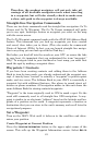

65
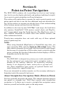
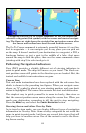
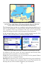
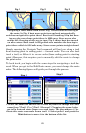
Navigating to a fishing spot using course line and Overlay Data boxes,
seen in lower right corner. From top to bottom, they are: bearing,
course, track, off course and steering arrow/distance.
The Steering Arrow overlay is a graphical arrow showing which way to
steer to the destination. It always points straight toward the destina-
tion, regardless of the map orientation. The steer arrow automatically
shows the distance from the current position to the destination.
In the example figure above, the boat is headed straight toward a fish-
ing spot, so the steering arrow is pointing straight ahead.
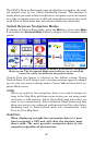
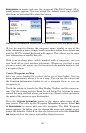
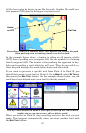
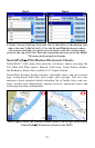
Select an overlay data item (left) to display its information screen.
In addition to the steer arrow, the most commonly used Overlay Data
for point-to-point navigation are described below:
Track: The actual direction you are traveling over the ground. Shown
in degrees in true or magnetic format.
Bearing: The direction to the current destination from your current posi-
tion, shown in degrees true or magnetic. Steer so your Track matches the
Bearing and you will be headed straight for your destination.