


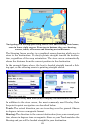


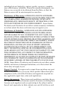

73
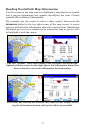
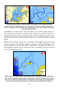
These figures show the lake detail included in the enhanced lake
maps. More detail appears as you zoom in. This is a man-made lake;
these examples clearly show the submerged river and stream channels
that formed the lake.
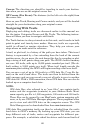
In addition to underwater contour features, these lake maps show en-
hanced shoreline features, small islands and various bottom structures.
Underwater features on man-made lakes reflect conditions prior to in-
undation of the lake. Each depth contour line is labeled with its actual
depth.
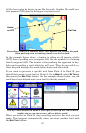
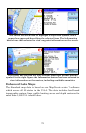
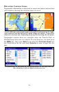
With enhanced lake maps you can identify submerged structures such
as rivers and creek channels, ponds, streams, roads, foundations, rail-
roads, pipelines, oil and gas wells, foundations, bridges, etc. However,
the amount of detail varies from one lake to another. All lakes do not
have this enhanced detail.
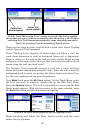
Fishermen will appreciate that underwater features, such as bridges,
old creek channels, roads and other items, can be identified by using
the cursor. Select a lake feature with the cursor and a pop up box ap-
pears, identifying the feature. An old house foundation is shown.