


71
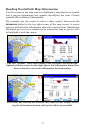
Reading NauticPath Map Information
Use the cursor on the map screen to highlight a map feature or symbol
and a pop-up information box appears identifying the item. Certain
symbols offer additional information.
For example, use the cursor to select a chart symbol, then press the
INFORMATION button in the top right corner of the map screen. A screen
appears with detailed information about the selected item. Information
for almost any on-screen symbol can be accessed as long as you are able
to highlight it with the cursor.
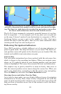
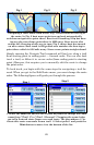
The Port Aransas, Texas tide symbol in the left figure has been high-
lighted with the cursor. In the right figure the Information button has
been selected to view tidal information for that station.
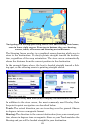
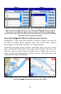
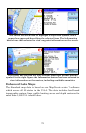
The cursor has selected the Aransas Pass tidal current station. Press-
ing the Information button calls up the tidal current table.